Difference between revisions of "Kinver Edge"
(Created page with '{{Infobox hill |name=Kinver Edge |county 1=Staffordshire |county 2=Worcestershire |picture=View of Kinver from Rock Houses.JPG |picture caption=Kinver seen from Holy Austin Rock …') |
|||
| Line 6: | Line 6: | ||
|picture caption=Kinver seen from Holy Austin Rock Houses | |picture caption=Kinver seen from Holy Austin Rock Houses | ||
|os grid ref=SO829824 | |os grid ref=SO829824 | ||
| + | |latitude=52.439299 | ||
| + | |longitude=-2.252977 | ||
|height=538 feet | |height=538 feet | ||
}} | }} | ||
| Line 38: | Line 40: | ||
*[http://www.stourbridge.com/htm/kinver.htm Internet Guide to Stourbridge Kinver Page] | *[http://www.stourbridge.com/htm/kinver.htm Internet Guide to Stourbridge Kinver Page] | ||
*[http://www.bbc.co.uk/radio4/factual/opencountry_20060603.shtml BBC Radio 4 documentary about Kinver Edge (listen online)] | *[http://www.bbc.co.uk/radio4/factual/opencountry_20060603.shtml BBC Radio 4 documentary about Kinver Edge (listen online)] | ||
| − | |||
| − | |||
[[Category:National Trust properties in Staffordshire]] [[Category:National Trust properties in Worcestershire]] | [[Category:National Trust properties in Staffordshire]] [[Category:National Trust properties in Worcestershire]] | ||
Latest revision as of 14:40, 22 September 2018
| Kinver Edge | |
| Staffordshire, Worcestershire | |
|---|---|
 Kinver seen from Holy Austin Rock Houses | |
| Summit: | 538 feet SO829824 52°26’21"N, 2°15’11"W |
Kinver Edge is a high heath and woodland escarpment on the border of Staffordshire and Worcestershire, rising just west of Kinver. It is to be found about four miles west of Stourbridge and four miles north of Kidderminster. The ridge of Kinver Edge forms the county boundary. The hill is owned by the National Trust.
Geography
Kinver Edge is situated to the east of the Severn Valley. It is preserved as green belt land at the very edge of the urban Black Country. Kinver Edge rises to 538 feet above sea level at the summit, and provides views to the Clent Hills, Shatterford Hill, Dudley, Wenlock Edge, Malvern Hills and the Shropshire Hills.
The Edge is topped with Bunter pebbles and is subject to erosion.
The heathland and woodland on Kinver Edge are inhabited by wildlife, including adders and common lizards present on the heaths. Buzzards, jays and great spotted woodpeckers ply the skies and badgers, foxes and many other bird species inhabit the woods. The area around the summit is mainly heathland, with birch, oak and sweet chestnut trees in the woods at the northern end. Kingsford Country Park is on the southern end of the edge, and entirely in Worcestershire, made up of coniferous plantation woodlands.
History
Kinver Edge is a remnant of the Mercian forest, although much planting dates from post-1945. There are two Iron Age hillforts on Kinver Edge the larger one Kinver Edge Hillfort, is at the northern end, while the other is at the southern end, on a promontory known as Drakelow Hill.
Kinver Edge is home to the last troglodyte dwellings occupied in England, with a set of complete cave-houses excavated into the local sandstone. One of the rocks, "Holy Austin", was a hermitage until the Reformation. The Holy Austin rock houses were inhabited until the 1950s. They are now owned by the National Trust. The cottage gardens and an orchard are being replanted and restored.
The area has been a popular local tourist destination since Edwardian times, when an electric tramway, the Kinver Light Railway, connected Kinver to the Birmingham tram system.
Contemporary uses
The primary economic activity is tourism and estate management. The Staffordshire Way long-distance footpath passes over the summit. The Country Park is used for mountain biking.
Pictures
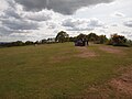
Summit of Kinver Edge
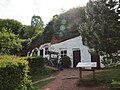
Holy Austin Rock Houses

Unrestored rock houses


Outside links
- Kinver Edge information at the National Trust
- Internet Guide to Stourbridge Kinver Page
- BBC Radio 4 documentary about Kinver Edge (listen online)