Difference between revisions of "Tarbat"
(Created page with "{{county|Ross}} Tarbat Old Church '''Tarbat''' is a parish formed by the Tarbat peninsula on the east cost of Easter Ross, bounded o...") |
|||
| (2 intermediate revisions by the same user not shown) | |||
| Line 1: | Line 1: | ||
{{county|Ross}} | {{county|Ross}} | ||
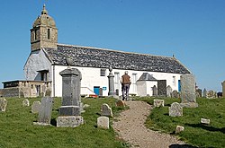
[[File:Tarbat Old Church.jpg|thumb|250px|Tarbat Old Church]] | [[File:Tarbat Old Church.jpg|thumb|250px|Tarbat Old Church]] | ||
| − | '''Tarbat''' is a parish formed by the Tarbat peninsula on the east cost of Easter Ross | + | '''Tarbat''' is a parish formed by the Tarbat peninsula on the east cost of Easter Ross. The name 'Tarbat' is from the Gaelic ''tairbeart'' meaning "isthmus". |
| + | The peninsula faces the open waters of the [[Moray Firth]], a part of the North Sea, and is bounded on the north by the [[Dornoch Firth]] and on the south by the [[Cromarty Firth]] and [[Nigg Bay]]. To the south, separated by the Cromarty Firth, is the [[Black Isle]], and like the Black Isle, the Tarbat Peninsula lies in both [[Ross-shire]] and [[Cromartyshire]] (detached parts Nos. 5, 6 and 7). | ||
| + | |||
| + | The head of the peninsula is [[Tarbat Ness]], and here stands the [[Tarbat Ness Lighthouse]]. | ||
| + | |||
| + | Tarbat parish contains the villages of [[Balnabruach]], [[Portmahomack]], and Rockfield. | ||
| + | |||
| + | Three contiguous villages sitting in the middle of the open North Sea coast of the Tarbat Peninsula, namely [[Hilton of Cadboll]], [[Balintore, Ross-shire|Balintore]] and [[Shandwick]] are collectively known as 'the [[Seaboard Villages]]'. All are in Ross-shire | ||
| + | |||
| + | ==Location== | ||
Location map: {{wmap|57.832483|-3.816693}} | Location map: {{wmap|57.832483|-3.816693}} | ||
| + | |||
| + | ==Outisde links== | ||
| + | {{commons}} | ||
| + | *[http://seaboardhistory.com/ Seaboard History] - online archive of the social history of the Seaboard Villages; Hilton, Balintore, and Shandwick | ||
| + | |||
[[Category:Towns and villages in Cromartyshire]] | [[Category:Towns and villages in Cromartyshire]] | ||
[[Category:Towns and villages in Ross-shire]] | [[Category:Towns and villages in Ross-shire]] | ||
| + | [[Category:Peninsulas of Cromartyshire]] | ||
| + | [[Category:Peninsulas of Ross-shire]] | ||
{{stub}} | {{stub}} | ||
Latest revision as of 13:52, 2 January 2020
Tarbat is a parish formed by the Tarbat peninsula on the east cost of Easter Ross. The name 'Tarbat' is from the Gaelic tairbeart meaning "isthmus".
The peninsula faces the open waters of the Moray Firth, a part of the North Sea, and is bounded on the north by the Dornoch Firth and on the south by the Cromarty Firth and Nigg Bay. To the south, separated by the Cromarty Firth, is the Black Isle, and like the Black Isle, the Tarbat Peninsula lies in both Ross-shire and Cromartyshire (detached parts Nos. 5, 6 and 7).
The head of the peninsula is Tarbat Ness, and here stands the Tarbat Ness Lighthouse.
Tarbat parish contains the villages of Balnabruach, Portmahomack, and Rockfield.
Three contiguous villages sitting in the middle of the open North Sea coast of the Tarbat Peninsula, namely Hilton of Cadboll, Balintore and Shandwick are collectively known as 'the Seaboard Villages'. All are in Ross-shire
Location
Location map: 57°49’57"N, 3°49’0"W
Outisde links
| ("Wikimedia Commons" has material about Tarbat) |
- Seaboard History - online archive of the social history of the Seaboard Villages; Hilton, Balintore, and Shandwick
