Difference between revisions of "River Aire"
m |
(→Towns and villages) |
||
| (4 intermediate revisions by 2 users not shown) | |||
| Line 2: | Line 2: | ||
The '''River Aire''' is a major river in [[Yorkshire]], 71 miles long. Part of the river is canalised, and is known as the [[Aire and Calder Navigation]]. It flows entirely though the [[West Riding of Yorkshire]] and in the hills it cuts a valey, [[Airedale]], which forms one of the famed [[Yorkshire Dales]] | The '''River Aire''' is a major river in [[Yorkshire]], 71 miles long. Part of the river is canalised, and is known as the [[Aire and Calder Navigation]]. It flows entirely though the [[West Riding of Yorkshire]] and in the hills it cuts a valey, [[Airedale]], which forms one of the famed [[Yorkshire Dales]] | ||
| − | The Aire rises at [[Malham Tarn]], flowing underground to Aire Head, near [[Malham]], in [[ | + | The Aire rises at [[Malham Tarn]], flowing underground to Aire Head, near [[Malham]], in the [[West Riding of Yorkshire]], and then flows through [[Gargrave]] and [[Skipton]]. It passes through the former industrial areas of [[Keighley]], [[Bingley]], [[Saltaire]] and [[Shipley]]. It then passes through [[Leeds]] and on to the villages of [[Swillington]] and [[Woodlesford]]. |
At [[Castleford]] is the confluence of the Aire and [[River Calder, Yorkshire|Calder]]; just downstream of the confluence was the ford where the ancient British road, used by the Romans, crossed on its way north to [[York]]. It passes [[Knottingley]] and in its lower reaches below the dale pass through the low lands of the West Riding. | At [[Castleford]] is the confluence of the Aire and [[River Calder, Yorkshire|Calder]]; just downstream of the confluence was the ford where the ancient British road, used by the Romans, crossed on its way north to [[York]]. It passes [[Knottingley]] and in its lower reaches below the dale pass through the low lands of the West Riding. | ||
| Line 9: | Line 9: | ||
==Name of the river== | ==Name of the river== | ||
| − | The name "Aire" is possibly derived from the British language and a word reconstructed as *Isara, meaning "strong river". The Aire could have been the ''Winwæd'' written about in Old English, from the elements ''winnan'' or ''win | + | The name "Aire" is possibly derived from the British language and a word reconstructed as *Isara, meaning "strong river". The Aire could have been the ''Winwæd'' written about in Old English, from the elements ''winnan'' or ''win'' ("strife", "fight") and ''wæd'' ("shallow water", "ford"). Others however have proposed that the ''Winwæd'' is the [[River Went|Went]] (also called the "wynt" in Old English) or the [[Cock Beck]]. Still others have claimed that it is actually the name of the battle and not the body of water itself.<ref>{{cite web|url=http://web.onetel.net.uk/~gedburnell/fairburn.htm |title=A Brief History of the Fairburn Area |publisher=Web.onetel.net.uk |accessdate=5 August 2011}}</ref><ref>''Archaeologia Aeliana, Or, Miscellaneous Tracts Relating to Antiquity'' - published by Society of Antiquaries of Newcastle upon Tyne, 1857</ref> |
==Towns and villages== | ==Towns and villages== | ||
| Line 28: | Line 28: | ||
*[[Silsden]] | *[[Silsden]] | ||
*[[Steeton]] | *[[Steeton]] | ||
| − | *[[Utley, | + | *[[Utley, Yorkshire|Utley]] |
*[[Keighley]] | *[[Keighley]] | ||
*[[Riddlesden]] | *[[Riddlesden]] | ||
| Line 53: | Line 53: | ||
*[[Chapel Haddlesey]] | *[[Chapel Haddlesey]] | ||
*[[Temple Hirst]] | *[[Temple Hirst]] | ||
| − | *[[ | + | *[[Hensall]] |
*[[Gowdall]] | *[[Gowdall]] | ||
*[[Snaith]] | *[[Snaith]] | ||
| − | *[[Rawcliffe, | + | *[[Rawcliffe, West Riding|Rawcliffe]] |
*[[Newland, Yorkshire|Newland]] | *[[Newland, Yorkshire|Newland]] | ||
*[[Airmyn]] | *[[Airmyn]] | ||
Latest revision as of 12:57, 11 April 2021

The River Aire is a major river in Yorkshire, 71 miles long. Part of the river is canalised, and is known as the Aire and Calder Navigation. It flows entirely though the West Riding of Yorkshire and in the hills it cuts a valey, Airedale, which forms one of the famed Yorkshire Dales
The Aire rises at Malham Tarn, flowing underground to Aire Head, near Malham, in the West Riding of Yorkshire, and then flows through Gargrave and Skipton. It passes through the former industrial areas of Keighley, Bingley, Saltaire and Shipley. It then passes through Leeds and on to the villages of Swillington and Woodlesford.
At Castleford is the confluence of the Aire and Calder; just downstream of the confluence was the ford where the ancient British road, used by the Romans, crossed on its way north to York. It passes Knottingley and in its lower reaches below the dale pass through the low lands of the West Riding.
The River Aire empties into the River Ouse at Airmyn, 'myn' being an Old English word for 'river mouth'.
Name of the river
The name "Aire" is possibly derived from the British language and a word reconstructed as *Isara, meaning "strong river". The Aire could have been the Winwæd written about in Old English, from the elements winnan or win ("strife", "fight") and wæd ("shallow water", "ford"). Others however have proposed that the Winwæd is the Went (also called the "wynt" in Old English) or the Cock Beck. Still others have claimed that it is actually the name of the battle and not the body of water itself.[1][2]
Towns and villages
from source

(Joins River Ouse)
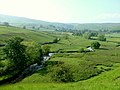
South of Malham
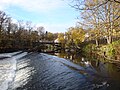
Bingley
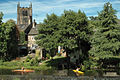
Kirkstall Abbey

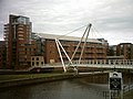
The 2008 bridge over the River Aire at Castleford

Castleford
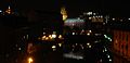
Leeds city centre
Clarence Dock, Leeds
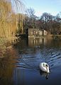
Pollard Bridge, Newlay near Leeds


Outside links
| ("Wikimedia Commons" has material about River Aire) |
References
- ↑ "A Brief History of the Fairburn Area". Web.onetel.net.uk. http://web.onetel.net.uk/~gedburnell/fairburn.htm. Retrieved 5 August 2011.
- ↑ Archaeologia Aeliana, Or, Miscellaneous Tracts Relating to Antiquity - published by Society of Antiquaries of Newcastle upon Tyne, 1857