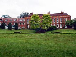
Sidcup
From Wikishire
Revision as of 15:25, 26 July 2013 by PLH (Talk | contribs) (Created page with '{{Infobox town |name=Sidcup |county=Kent |picture=FrognalHouse.jpg |picture caption=Frognal House |os grid ref=TQ461718 |latitude=51.4263 |longitude=0.1024 |post town=Sidcup |pos…')
| Sidcup | |
| Kent | |
|---|---|
 Frognal House | |
| Location | |
| Grid reference: | TQ461718 |
| Location: | 51°25’35"N, 0°6’9"E |
| Data | |
| Post town: | Sidcup |
| Postcode: | DA14, DA15 |
| Dialling code: | 020 |
| Local Government | |
| Council: | Bexley |
| Parliamentary constituency: |
Old Bexley and Sidcup |
Sidcup is a town in Kent. It was once in a rural area and contains many large houses and manors, but today sits in the southeast of the Greater London conurbation.
This Kent article is a stub: help to improve Wikishire by building it up.