Canning Town
From Wikishire
Revision as of 10:45, 7 July 2013 by PLH (Talk | contribs) (Created page with '{{Infobox town |name=Canning Town |county=Essex |picture=Canning_Town,_Former_St_Luke's_Church_-_geograph.org.uk_-_762025.jpg |picture caption= St Luke's Church, now used as a co…')
| Canning Town | |
| Essex | |
|---|---|
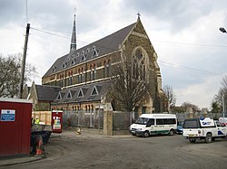
 St Luke's Church, now used as a community centre | |
| Location | |
| Grid reference: | TQ4081 |
| Location: | 51°30’54"N, 0°1’34"E |
| Data | |
| Post town: | London |
| Postcode: | E16 |
| Dialling code: | 020 |
| Local Government | |
| Council: | Newham |
| Parliamentary constituency: |
West Ham |
Canning Town is a town in Essex, within the London metropolitan conurbation. It is situated between Plaistow to the north, Royal Victoria Dock to the south, Beckton to the east, and, across the River Lea in Middlesex, Poplar to the west.
The town was developed to house dock workers. It is among the most socially deprived in the country.
{stub}}