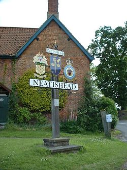
Neatishead
From Wikishire
Revision as of 22:22, 23 April 2014 by RB (Talk | contribs) (Created page with '{{Infobox town |name=Neatishead |county=Norfolk |picture=Neatishead 024654 f6398b46-by-GaryReggae.jpg |picture caption=Neatishead village sign |os grid ref=TG342210 |latitude=52.…')
| Neatishead | |
| Norfolk | |
|---|---|
 Neatishead village sign | |
| Location | |
| Grid reference: | TG342210 |
| Location: | 52°44’9"N, 1°28’4"E |
| Data | |
| Population: | 537 |
| Post town: | Norwich |
| Postcode: | NR12 |
| Local Government | |
| Council: | North Norfolk |
Neatishead is a little village in Norfolk, found within The Norfolk Broads and to the west of Barton Broad. Boat access to Neatishead from the broad is by way of Limekiln Dyke, a narrow channel leading off the broad.
The civil parish has an area of 3 square miles and in the 2001 had a population of 537, in 235 households.
The village is known for the nearby RAF Neatishead radar station.
Outside links
| ("Wikimedia Commons" has material about Neatishead) |
- Information from Genuki Norfolk on Neatishead