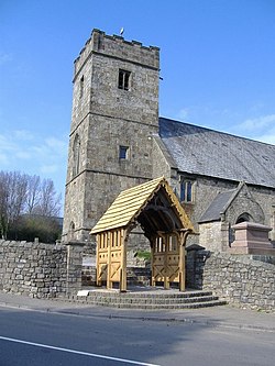
Trevethin
From Wikishire
Revision as of 10:46, 29 July 2014 by Owain (Talk | contribs) (Created page with "{{Infobox town |name=Trevethin |county=Monmouthshire |picture=St Cadoc's Church, Trevethin - geograph.org.uk - 399101.jpg |picture caption=St Cadoc's Church |os grid ref=SO282...")
| Trevethin | |
| Monmouthshire | |
|---|---|
 St Cadoc's Church | |
| Location | |
| Grid reference: | SO282022 |
| Location: | 51°42’48"N, 3°2’22"W |
| Data | |
| Population: | 5,147 (2011) |
| Post town: | Pontypool |
| Postcode: | NP4 |
| Dialling code: | 01495 |
| Local Government | |
| Council: | Torfaen |
| Parliamentary constituency: |
Torfaen |
Trevethin is a parish and suburb of Pontypool in Monmouthshire. It is a modern suburb, built around a small village in the 1960s and '70s and is all but merged with nearby Penygarn.
Trevethin is situated on the southernmost point of the Brecon Beacons National Park. Near to Trevethin are various famous landmarks including the Folly Tower and Shell Grotto both of which were originally built by the Hanbury family during the 18th century.
Outside links
- Pontypool Past & Present - Pontypool's only community website!
- www.geograph.co.uk : photos of Trevethin and surrounding area
- Trevethin on Genuki