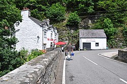
Llanfihangel Glyn Myfyr
| Llanfihangel Glyn Myfyr | |
| Denbighshire | |
|---|---|
 The Crown Inn | |
| Location | |
| Grid reference: | SH9949 |
| Location: | 53°1’52"N, 3°30’22"W |
| Data | |
| Population: | 195 (2001) |
| Post town: | Corwen |
| Postcode: | LL21 |
| Dialling code: | 01490 |
| Local Government | |
| Council: | Conwy |
| Parliamentary constituency: |
Clwyd West |
Llanfihangel Glyn Myfyr is a village and parish in Denbighshire. It is located on the Afon Alwen, at the south western edge of the Clocaenog Forest, 2½ miles east of Cerrigydrudion and nine miles north-west of Corwen, Merionethshire. At the 2001 census the parish had a population of 195.[1]
The old farmhouse at Bodtegir, south east of the village, built in 1655 by William Salesbury, the Royalist governor of Denbigh Castle during the Civil War, is Grade II* listed,[2] as is Saint Michael's Church.[3] Pont Llyn Gigfran, which carries a minor road to Betws Gwerfil Goch over the Afon Alwen, in the south east of the community, is Grade II listed.[4]
The antiquary Owen Jones, who compiled The Myvyrian Archaiology of Wales, published between 1801 and 1807, was born in the parish.[5][6] He died in 1814 and was buried in London, but his gravestone was removed to Llanfihangel Glyn Myfyr after the churchyard at All-Hallows-the-Less was damaged by bombing in World War II.[7]
References
- ↑ "Census 2001: Parish Headcounts: Conwy". Neighbourhood Statistics. Office for National Statistics. http://www.neighbourhood.statistics.gov.uk/dissemination/viewFullDataset.do?instanceSelection=03070&productId=779&$ph=60_61&datasetInstanceId=3070&startColumn=1&numberOfColumns=8&containerAreaId=790561. Retrieved 9 April 2013.
- ↑ "Bodtegir Old Farmhouse". Listed Building Database Record. Cadw. http://jura.rcahms.gov.uk/cadw/cadw_eng.php?id=95. Retrieved 10 April 2013.
- ↑ "Church of St Michael, Llanfihangel Glyn Myfyr". British Listed Buildings. http://www.britishlistedbuildings.co.uk/wa-92-church-of-st-michael-llanfihangel-glyn-myfyr. Retrieved 10 April 2013.
- ↑ "Pont Llyn Gigfran (partly in Llanfihangel Glyn Myfyr Community), Betws Gwerfil Goch". British Listed Buildings. British Listed Buildings Online. http://www.britishlistedbuildings.co.uk/wa-96-pont-llyn-gigfran-partly-in-llanfihangel-gly/osmap. Retrieved 9 April 2013.
- ↑ "Y Myvyrian Archaiology". Jones' Celtic Encyclopedia. Mary Jones. 2003. http://www.maryjones.us/jce/myvyrian.html. Retrieved 9 April 2013.
- ↑ Phillips, Geraint (2008). "Jones, Owen (1741–1814)" (Online). Oxford Dictionary of National Biography. Oxford University Press. http://www.oxforddnb.com/view/article/15065. Retrieved 11 June 2009.
- ↑ Jenkins, R.T.; Ramage, Helen M. (1951). A History of the Honourable Society of Cymmrodorion and of the Gwyneddigion and Cymreigyddion Societies (1751–1951). Y Cymmrodor. 50. London: Honourable Society of Cymmrodorion. pp. 93–4.
Outside links
| ("Wikimedia Commons" has material about Llanfihangel Glyn Myfyr) |
- A Vision of Britain Through Time
- British Listed Buildings
- Clwyd Churches
- Eastern Conwy Churches Survey
- Genuki
- Geograph
- Office for National Statistics
This Denbighshire article is a stub: help to improve Wikishire by building it up.