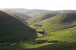
Barrow Burn
From Wikishire
Revision as of 23:34, 15 November 2015 by RB (Talk | contribs) (Created page with "{{Infobox town |name=Barrow Burn |county=Northumberland |picture=Barrowburn and Windyhaugh on the Upper Coquet - geograph.org.uk - 378485.jpg |picture caption=Barrowburn and W...")
| Barrow Burn | |
| Northumberland | |
|---|---|
 Barrowburn and Windyhaugh | |
| Location | |
| Grid reference: | NT865105 |
| Location: | 55°23’17"N, 2°12’50"W |
| Data | |
| Post town: | Morpeth |
| Postcode: | NE65 |
| Local Government | |
| Council: | Northumberland |
| Parliamentary constituency: |
Berwick-upon-Tweed |
Barrow Burn is a hamlet in Northumberland. It is found in the very north of the county, in the Cheviot Hills and on the uppermost reaches of the River Coquet, in a place where the river's steep valley relents for a moment as it is fed by burns from the surrounding fells to provide a space for a settlement.
The hamlet is within Alwinton parish and in the shadow of Shillhope Law (1,644 feet). It is also at the edge of the army firing ranges. There is a bunkhouse in the village for passing travellers.
References
Outside links
| ("Wikimedia Commons" has material about Barrow Burn) |