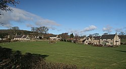
Holystone, Northumberland
From Wikishire
Revision as of 17:53, 13 January 2016 by RB (Talk | contribs) (Created page with "{{Infobox town |name=Holystone |county=Northumberland |picture=Holystone - geograph.org.uk - 1773013.jpg |picture caption=Holystone |os grid ref=NT955025 |latitude=55.317 |l...")
| Holystone | |
| Northumberland | |
|---|---|
 Holystone | |
| Location | |
| Grid reference: | NT955025 |
| Location: | 55°19’1"N, 2°4’19"W |
| Data | |
| Post town: | Morpeth |
| Postcode: | NE65 |
| Dialling code: | 01669 |
| Local Government | |
| Council: | Northumberland |
| Parliamentary constituency: |
Berwick-upon-Tweed |
Holystone is a small village in Northumberland. The village is in Coquetdale, and sits just within the edge of the Northumberland National Park, on the north bank of the River Coquet.
A significant landmark is Holy Well, traditionally the site of early Christian baptisms, and the source of Holystone's water supply.[1]
In the early 12th century Holystone became the home of a priory of Augustinian Canonesses. The priory buildings were demolished during the reformation in 1541.[2]
In 1903, Newcastle upon Tyne-based architect Frank West Rich purchased Dues Hill Grange and 3,000 acres of land in Holystone, which he subsequently renovated.[3]
Outside links
| ("Wikimedia Commons" has material about Holystone, Northumberland) |
- Holystone in the National Park
- Photographs, concentrating on its Lady's Well
- Illustrated walk through Holystone woods, Northumberland
References
- ↑ Holystone: The History - Northumberland National Park
- ↑ "Holystone Priory, Holystone (Harbottle)", Keys to the Past web site. Retrieved 16 July 2014
- ↑ Armstrong, Barrie; Armstrong, Wendy (2013). The Arts and Crafts Movement in the North East of England. A Handbook. Wetherby: Oblong Creative Ltd. p. 235. ISBN 9 780957599215.