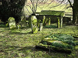
Unthank, Dumfriesshire
From Wikishire
Revision as of 13:01, 5 July 2016 by RB (Talk | contribs) (Created page with "{{Infobox town |name=Unthank |county=Dumfriesshire |picture=The old graveyard at Unthank.jpg |picture caption=The old graveyard at Unthank |os grid ref= |latitude=55.243181 |l...")
| Unthank | |
| Dumfriesshire | |
|---|---|
 The old graveyard at Unthank | |
| Location | |
| Location: | 55°14’35"N, 2°57’59"W |
| Data | |
| Local Government | |
| Council: | Dumfries and Galloway |
Unthank is a hamlet in Dumfriesshire, by the bank of the Ewes Water, which is a tributary of the River Esk.
There is very little here: just a farm today, but there may also been seen the remains of a church, and the earthworks of an old farmstead on the hillside. The Unthank Burn runs down to the Ewes Water here.
References
| ("Wikimedia Commons" has material about Unthank, Dumfriesshire) |
This Dumfriesshire article is a stub: help to improve Wikishire by building it up.