Birtley, Shropshire
From Wikishire
Revision as of 22:40, 7 February 2017 by RB (Talk | contribs) (Created page with "{{Infobox town |name=Birtley |county=Shropshire |picture=Tiny House At Birtley - geograph.org.uk - 256386.jpg |picture caption=A small house in the hamlet |os grid ref=SO47690...")
| Birtley | |
| Shropshire | |
|---|---|
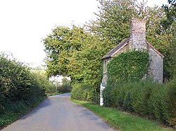
 A small house in the hamlet | |
| Location | |
| Grid reference: | SO476906 |
| Location: | 52°30’40"N, 2°46’19"W |
| Data | |
| Post town: | Church Stretton |
| Postcode: | SY6 |
| Dialling code: | 01694 |
| Local Government | |
| Council: | Shropshire |
| Parliamentary constituency: |
Ludlow |
Birtley is a hamlet in Shropshire, a short distance to the west of the village of Ticklerton, in countryside to the south-east of the market town of Church Stretton. Close by too is Eaton-under-Heywood (to whose civil parish t has been allocated). The village sits at an altitude of 640 feet above sea level.
Outside links
| ("Wikimedia Commons" has material about Birtley, Shropshire) |