Higham, Derbyshire
From Wikishire
Revision as of 13:04, 28 May 2021 by RB (Talk | contribs) (Created page with "{{Infobox town |name=Higham |county=Derbyshire |picture=Higham_Greyhound_pub_153142_9f80c0fd.jpg |picture caption=The main street, Higham |os grid ref=SK391590 |latitude=53.12...")
| Higham | |
| Derbyshire | |
|---|---|
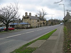
 The main street, Higham | |
| Location | |
| Grid reference: | SK391590 |
| Location: | 53°7’37"N, 1°25’1"W |
| Data | |
| Post town: | Alfreton |
| Postcode: | DE55 |
| Dialling code: | 01773 |
| Local Government | |
| Council: | North East Derbyshire |
| Parliamentary constituency: |
Bolsover |
Higham is a small village in Derbyshire. It is located on the B6013 and A61 roads. Nearby villages include Shirland, Stretton, Alfreton and Clay Cross. 'Higham' is a name of Anglo-Saxon origin.
The village has two public houses, the Crown Inn and the Greyhound. The village does not have a church of its own, sharing St Leonards church with neighbouring Shirland.
Outside links
| ("Wikimedia Commons" has material about Higham, Derbyshire) |