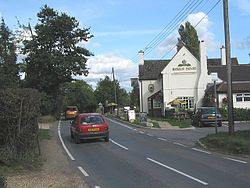
Durley Street
From Wikishire
Revision as of 19:45, 2 October 2022 by RB (Talk | contribs) (Created page with "{{Infobox town |name=Durley Street |county=Hampshire |picture=Durley Street (road and village) - geograph.org.uk - 57205.jpg |picture caption=Durley Street |os grid ref=SU5281...")
| Durley Street | |
| Hampshire | |
|---|---|
 Durley Street | |
| Location | |
| Grid reference: | SU528177 |
| Location: | 50°57’25"N, 1°14’59"W |
| Data | |
| Post town: | Southampton |
| Postcode: | SO24 |
| Dialling code: | 01962 |
| Local Government | |
| Council: | Winchester |
| Parliamentary constituency: |
Meon Valley |
Durley Street is a village in Hampshire, approximately seven north-east of Southampton, and a mile north-east of Durley, a village no bigger. To the east it almost runs into Bishops Waltham.