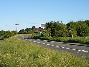
Jaw Hill
From Wikishire
Revision as of 12:34, 22 August 2023 by RB (Talk | contribs) (Created page with "{{Infobox hill |name=Jaw Hill |county=Yorkshire |riding=West |range= |picture=Jaw Hill - geograph.org.uk - 830812.jpg |picture caption=Jaw Hill |os grid ref=SE293233 |latitude...")
| Jaw Hill | |
| Yorkshire | |
|---|---|
 Jaw Hill | |
| Summit: | 335 feet SE293233 53°42’21"N, 1°33’26"W |
Jaw Hill is a small hill, climbing to just 335 feet above sea level, in the West Riding of Yorkshire, just north-west of Kirkhamgate, in the narrow gap between the suburbs of Wakefield and of Dewsbury.
A large square cropmark enclosure was investigated in 1995, when it was thought to be a possible Roman marching camp. The site had V-shaped east and west ditches, both of which had evidence for a revetted defensive bank with lines of post-holes.
The base of a greyware vessel dating from the 2nd to 4th century was found on the site.[1]
References
- ↑ "Jaw Hill, Kirkhamgate". Archaeology Data Service. https://archaeologydataservice.ac.uk/archsearch/record.xhtml. Retrieved 12 May 2020.