A County top is the highest point of a county. A county top need not be in the heart of a county; many indeed are at the edges, where the county boundary runs over a ridge or watershed. A few are on the border of the county and may be the top of two counties.
The highest of them all is the magnificent Ben Nevis, the highest ground in the British Isles and consequently the county top of Inverness-shire, and the lowest the modestly named Boring Field in Huntingdonshire, a county not known for hills.
County tops of the United Kingdom
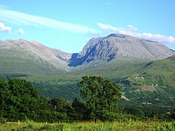
Ben Nevis, Inverness-shire, highest point in the United Kingdom
Slieve Donard, Downshire, highest mountain in Northern Ireland
A top which is the highest point in two different counties has an asterisk; *
| County
|
Hill
|
Height (ft)
|
Height (m)
|
Grid reference
|
| Aberdeenshire
|
Ben Macdhui*
|
4,295
|
1,309
|
NN988989
|
| Anglesey
|
Holyhead Mountain
|
722
|
220
|
SH2185882948
|
| Angus
|
Glas Maol
|
3,504
|
1,068
|
NO166765
|
| Antrim
|
Trostan
|
1,808
|
551
|
D17952360
|
| Argyllshire
|
Bidean nam Bian
|
3,773
|
1,150
|
NN143542
|
| Armagh
|
Slieve Gullion
|
1,880
|
573
|
J024201
|
| Ayrshire
|
Kirriereoch Hill shoulder
|
2,565
|
782
|
NX421870
|
| Banffshire
|
Ben Macdhui*
|
4,295
|
1,309
|
NN988989
|
| Bedfordshire
|
Dunstable Downs
|
797
|
243
|
TL0088119424
|
| Berkshire
|
Walbury Hill
|
974
|
297
|
SU3734861631
|
| Berwickshire
|
Meikle Says Law shoulder
|
1,746
|
532
|
NT581616
|
| Brecknockshire
|
Pen y Fan
|
2,906
|
886
|
SO0121221588
|
| Buckinghamshire
|
Haddington Hill
|
875
|
267
|
SP8907209088
|
| Buteshire
|
Goatfell, Arran
|
2,867
|
874
|
NR991415
|
| Caernarfonshire
|
Snowdon
|
3,560
|
1,085
|
SH6098954379
|
| Caithness
|
Morven
|
2,316
|
706
|
ND004285
|
| Cambridgeshire
|
deserted village near
Castle Camps
|
420
|
128
|
TL632418
|
| Cardiganshire
|
Pen Pumlumon Fawr
|
2,467
|
752
|
SN7897186945
|
| Carmarthenshire
|
Fan Foel
|
2,562
|
781
|
SN8214022338
|
| Cheshire
|
Black Hill
|
1,909
|
582
|
SE0781604687
|
| Clackmannanshire
|
Ben Cleuch
|
2,365
|
721
|
NN902006
|
| Cornwall
|
Brown Willy
|
1,378
|
420
|
SX1587280004
|
| Cromartyshire
|
Sgùrr Mòr
|
3,642
|
1,110
|
NH203718
|
| Cumberland
|
Scafell Pike
|
3,209
|
978
|
NY2154207217
|
| Denbighshire
|
Cadair Berwyn south summit
|
2,726
|
830
|
SJ0716532355
|
| Derbyshire
|
Kinder Scout
|
2,087
|
636
|
SK0851887520
|
| Devon
|
High Willhays
|
2,037
|
621
|
SX5802389203
|
| Dorset
|
Lewesdon Hill
|
915
|
279
|
ST4377801172
|
| Down
|
Slieve Donard
|
2,789
|
850
|
J357276
|
| Dumfriesshire
|
White Coomb
|
2,694
|
821
|
NT163151
|
| Dunbartonshire
|
Ben Vorlich
|
3,094
|
943
|
NN295124
|
| Durham
|
Burnhope Seat
|
2,447
|
746
|
NY7879037536
|
| East Lothian
|
Meikle Says Law
|
1,755
|
535
|
NT581617
|
| Essex
|
High Wood, Chrishall Common
|
482
|
147
|
TL4430136202
|
| Fermanagh
|
Cuilcagh*
|
2,182
|
665
|
H123280
|
| Fife
|
West Lomond
|
1,713
|
522
|
NO197066
|
| Flintshire
|
Moel Famau
|
1,817
|
555
|
SJ1610962667
|
| Glamorgan
|
Craig y Llyn
|
1,969
|
600
|
SN9068903156
|
| Gloucestershire
|
Cleeve Hill
|
1,082
|
330
|
SO9969624599
|
| Hampshire
|
Pilot Hill
|
938
|
286
|
SU3987560111
|
| Herefordshire
|
Black Mountains ridge
|
2,306
|
703
|
SO2558835051
|
| Hertfordshire
|
Pavis Wood
|
800
|
244
|
SP9142009190
|
| Huntingdonshire
|
Boring Field
|
263
|
80
|
TL0472071050
|
| Inverness-shire
|
Ben Nevis
|
4,409
|
1,344
|
NN166712
|
| Kent
|
Betsom's Hill
|
823
|
251
|
TQ4355556332
|
| Kincardineshire
|
Mount Battock
|
2,552
|
778
|
NO549844
|
| Kinross-shire
|
Innerdouny Hill
|
1,631
|
497
|
NO032073
|
| Kirkcudbrightshire
|
Merrick
|
2,766
|
843
|
NX427855
|
| Lanarkshire
|
Culter Fell
|
2,454
|
748
|
NT052290
|
| Lancashire
|
Coniston Old Man[1]
|
2,634
|
803
|
SD2723797827
|
| Leicestershire
|
Bardon Hill
|
912
|
278
|
SK4599213199
|
| Lincolnshire
|
Normanby Top, The Wolds
|
551
|
168
|
TF1211096470
|
| Londonderry
|
Sawel Mountain*
|
2,224
|
678
|
H618973
|
| Merionethshire
|
Aran Fawddwy
|
2,969
|
905
|
SH8627222386
|
| Middlesex
|
Bushey Heath
|
509
|
155
|
TQ1523593970
|
| Midlothian
|
Blackhope Scar
|
2,136
|
651
|
NT315483
|
| Monmouthshire
|
Chwarel y Fan
|
2,228
|
680
|
SO2581929416
|
| Montgomeryshire
|
Moel Sych
|
2,726
|
827
|
SJ0663231863
|
| Morayshire
|
Carn a' Ghille Chearr
|
2,329
|
710
|
NJ139298
|
| Nairnshire
|
Carn Glas-choire
|
2,162
|
659
|
NH891291
|
| Norfolk
|
Beacon Hill
|
343
|
105
|
TG1835941425
|
| Northamptonshire
|
Arbury Hill
|
738
|
225
|
SP5401558770
|
| Northumberland
|
The Cheviot
|
2,674
|
815
|
NT9090420522
|
| Nottinghamshire
|
Silverhill
|
671
|
205
|
SK4561760649
|
| Orkney
|
Ward Hill, Hoy
|
1,578
|
481
|
HY228022
|
| Oxfordshire
|
Bald Hill
|
843
|
257
|
SU7288595775?
|
| Peeblesshire
|
Broad Law*
|
2,756
|
840
|
NT146235
|
| Pembrokeshire
|
Foel Cwmcerwyn
|
1,760
|
536
|
SN0940931161
|
| Perthshire
|
Ben Lawers
|
3,983
|
1,214
|
NN635414
|
| Radnorshire
|
Great Rhos
|
2,166
|
660
|
SO1821963902
|
| Renfrewshire
|
Hill of Stake
|
1,713
|
522
|
NS273630
|
| Ross-shire
|
Carn Eige
|
3,881
|
1,183
|
NH123261
|
| Roxburghshire
|
Auchop Cairn
|
2,422
|
738
|
NT456006
|
| Rutland
|
Cold Overton Park
|
646
|
197
|
SK8270808533
|
| Shetland
|
Ronas Hill
|
1,476
|
450
|
HU305834
|
| Selkirkshire
|
Broad Law[2]
|
2,756
|
840
|
NT146235
|
| Shropshire
|
Brown Clee Hill
|
1,772
|
540
|
SO5936686556
|
| Somerset
|
Dunkery Beacon
|
1,702
|
519
|
SS8914341587
|
| Staffordshire
|
Cheeks Hill
|
1,705
|
520
|
SK0260969904
|
| Stirlingshire
|
Ben Lomond
|
3,196
|
974
|
NN367028
|
| Suffolk
|
Great Wood, Rede
|
420
|
128
|
TL7869055863
|
| Surrey
|
Leith Hill
|
965
|
294
|
TQ1394943162
|
| Sussex
|
Black Down
|
918
|
280
|
SU9193529613
|
| Sutherland
|
Ben More Assynt
|
3,274
|
998
|
NC318201
|
| Tyrone
|
Sawel Mountain*
|
2,224
|
678
|
H618973
|
| Warwickshire
|
The Downs, Ilmington
|
794
|
242
|
SP199425
|
| West Lothian
|
Cairnpapple Hill (South Top)[3]
|
1,024
|
312
|
NS987711
|
| Westmorland
|
Helvellyn
|
3,117
|
950
|
NY3426015090
|
| Wigtownshire
|
Craigairie Fell
|
1,056
|
322
|
NX236736
|
| Wiltshire
|
Milk Hill
|
967
|
295
|
SU1041564341
|
| Worcestershire
|
Worcestershire Beacon
|
1,394
|
425
|
SO7688445223
|
| Yorkshire, East Riding
|
Bishop Wilton Wold
|
807
|
246
|
SE8218257026
|
| Yorkshire, North Riding
|
Mickle Fell
|
2,585
|
788
|
NY8058224534
|
| Yorkshire, West Riding
|
Whernside
|
2,415
|
736
|
SD7385081415
|
County tops of the Republic of Ireland
In the Irish Republic, nine Counties share a highest point with another county, whether a British or Irish county, and these are marked with an asterisk; *
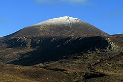
Carrauntoohil, County Kerry; the highest mountain in Munster and all Ireland
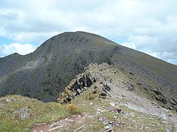
Lugnaquilla, County Wicklow. The highest mountain in Leinster

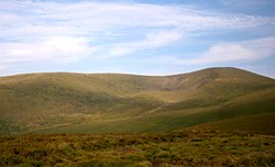
Mweelrea,
County Mayo. The highest mountain in Connaught
Outside links
References
- ↑ Lancashire's county top is believed to be the Old Man of Coniston but a claim is also made for nearby Swirl How, which is a few feet lower or higher, depending on exact measurement and perhaps on whether the cairn at the summit of the Old Man is included.
- ↑ Selkirkshire: possibly Ettrick Pen at 2,269 feet
- ↑ West Lothian: possibly The Knock at 1,023 feet


