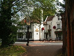
File:Carshalton Ponds, Surrey, one of the two sources of the River Wandle.jpg

From Wikishire
Jump to: navigation, search
Original file(874 × 546 pixels, file size: 628 KB, MIME type: image/jpeg)

This file is from a shared repository and may be used by other projects. The description on its file description page there is shown below.

Summary

Description
The slightly higher of the two Carshalton Ponds, Surrey, England at Photographed in July 2002. This is one of the two sources of the River Wandle. The corner of the Greyhound public house can be seen on the right. The road bends at this point and there is only a narrow pavement and low railing between the road and the pond. Two or three vehicles a year go through the railing and land up in the pond. The cones indicate that such an accident had happened shortly before this photograph was taken.
Date
Source Own work
Author RHaworth

grid reference TQ 278 644.

Camera location51° 21′ 54.11″ N, 0° 09′ 53.21″ W  Heading=78.75° Kartographer map based on OpenStreetMap.View this and other nearby images on: OpenStreetMapinfo

Licensing

Public domain This work has been released into the public domain by its author, RHaworth. This applies worldwide.

In some countries this may not be legally possible; if so:
RHaworth grants anyone the right to use this work for any purpose, without any conditions, unless such conditions are required by law.

Captions

Add a one-line explanation of what this file represents

Items portrayed in this file

depicts

51°21'54.11"N, 0°9'53.21"W

heading: 78.75 degree

image/jpeg

4b9db174746eb15ae84467e27df3e242c9d4b5f9

643,151 byte

546 pixel

874 pixel

File history

Click on a date/time to view the file as it appeared at that time.

Date/TimeThumbnailDimensionsUserComment
current02:45, 6 January 2015Thumbnail for version as of 02:45, 6 January 2015874 × 546 (628 KB)A P Monblatcropped

The following file is a duplicate of this file (more details):

The following page links to this file: