File:Eastington Manor farmhouse - geograph.org.uk - 1337353.jpg
From Wikishire
No higher resolution available.
Eastington_Manor_farmhouse_-_geograph.org.uk_-_1337353.jpg (640 × 480 pixels, file size: 67 KB, MIME type: image/jpeg)
|
This is a photo of listed building number 6594. |
Summary
| Description |
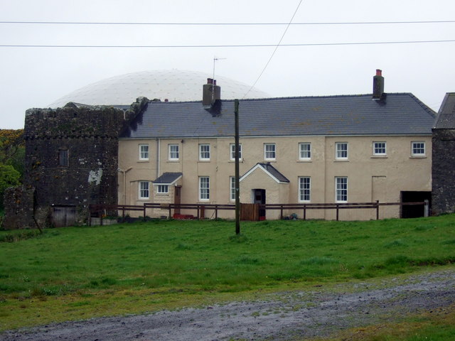
English: Eastington Manor farmhouse The long low C18 farmhouse appears to have been tacked on to a much earlier structure, left, probably a mediaeval fortified manor/castle, but there are signs of an additional gabled building to the west which has given rise to speculation about Eastington's original design and function. It was in the possession of the Perrotts in the C15. Latterly the place became a gentry house and farm belonging to the Meares family. Earlier names for it were Jestynton, Jesting town and Iseston.
See also http://www.texaco.co.uk/biodiversity/Manmade/eastington.htm |
| Date | |
| Source | From geograph.org.uk |
| Author | ceridwen |
| Attribution (required by the license) | ceridwen / Eastington Manor farmhouse / |
| Camera location | | View this and other nearby images on: OpenStreetMap |
|---|
_heading:45.00&language=en)
| Object location | | View this and other nearby images on: OpenStreetMap |
|---|
_heading:45.00&language=en)
Licensing

|
This image was taken from the Geograph project collection. See this photograph's page on the Geograph website for the photographer's contact details. The copyright on this image is owned by ceridwen and is licensed for reuse under the Creative Commons Attribution-ShareAlike 2.0 license.
|
This file is licensed under the Creative Commons Attribution-Share Alike 2.0 Generic license.
Attribution: ceridwen
- You are free:
- to share – to copy, distribute and transmit the work
- to remix – to adapt the work
- Under the following conditions:
- attribution – You must give appropriate credit, provide a link to the license, and indicate if changes were made. You may do so in any reasonable manner, but not in any way that suggests the licensor endorses you or your use.
- share alike – If you remix, transform, or build upon the material, you must distribute your contributions under the same or compatible license as the original.
File history
Click on a date/time to view the file as it appeared at that time.
| Date/Time | Thumbnail | Dimensions | User | Comment | |
|---|---|---|---|---|---|
| current | 01:02, 28 February 2011 | | 640 × 480 (67 KB) | GeographBot | == {{int:filedesc}} == {{Information |description={{en|1=Eastington Manor farmhouse The long low C18 farmhouse appears to have been tacked on to a much earlier structure, left, probably a mediaeval fortified manor/castle, but there are signs of an additio |
File usage
The following file is a duplicate of this file (more details):
- File:Eastington Manor farmhouse - geograph.org.uk - 1337353.jpg from a shared repository
The following page links to this file: