File:Taunton road map1948.jpg
From Wikishire

Size of this preview: 664 × 600 pixels. Other resolution: 266 × 240 pixels.
Original file (1,241 × 1,121 pixels, file size: 735 KB, MIME type: image/jpeg)
Summary
| Description |
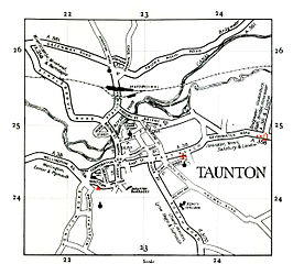
English: OS map of Taunton area, UK. |
| Date | |
| Source | Ordnance Survey map, originally uploaded on en.wiki under same name. |
| Author | Ordnance Survey |
Licensing
This work is an Ordnance Survey map over 50 years old, which is covered by Crown Copyright which in this case expires 50 years after publication. Ordnance Survey does however ask that they be credited and that the date of publication be given.
Any ancillary rights gained through the creation of the electronic version are granted as freely usable under any circumstances.
|
This work created by the United Kingdom Government is in the public domain.
This is because it is one of the following:
HMSO has declared that the expiry of Crown Copyrights applies worldwide (ref: HMSO Email Reply)
|
 |
Original upload log
The original description page is/was here (log). All following user names refer to en.wikipedia.
- 2006-12-02 23:05 Steinsky 1241x1121 (168 KB) ((OS map from 1948 {{oldOS}})
- 2007-04-06 22:31 Steinsky 1241x1121 (735 KB) (Tidied up)

|
The categories of this image need checking. You can do so here.
|
File history
Click on a date/time to view the file as it appeared at that time.
| Date/Time | Thumbnail | Dimensions | User | Comment | |
|---|---|---|---|---|---|
| current | 18:36, 25 August 2009 | | 1,241 × 1,121 (735 KB) | Sv1xv | {{Information |Description={{en|1=OS map of Taunton area, UK.}} |Source=Ordnance Survey map, originally uploaded on en.wiki under same name. |Author=Ordnance Survey |Date=1948 |Permission= |other_versions= }} =={{int:license}}== {{OldOS}} ==Original uplo |
File usage
The following file is a duplicate of this file (more details):
- File:Taunton road map1948.jpg from a shared repository
The following page links to this file: