File:The Town Hall at Barrow-in-Furness - geograph.org.uk - 1512056.jpg
Summary
| Description |
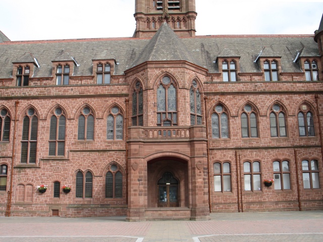
English: The Town Hall at Barrow-in-Furness The centre of Barrow-in-Furness is dominated by its fine red sandstone Town Hall. The building was the result of an architectural competition held in 1877, the winner of which was Belfast architect W. H. Lynn (1829-1915), a specialist in the design of imposing civic buildings in the Victorian Gothic style (other surviving examples of his work are the town halls at Chester and at Paisley, and the Belfast Central Library).
Construction of the Barrow-in-Furness Town Hall did not run smoothly. The Council's constant cost-cutting in its design delayed the start of construction until 1882, and work was later hampered by cracks appearing in its central tower - the results of economies forcing the contractor to use poor quality sandstone - which had to be dismantled and rebuilt. To reduce its weight the rebuilt tower was 13 feet shorter than originally designed. The Council's parsimony even extended to querying Lynn's purchase of a pitch-pine flagstaff when Norwegian spruce had been specified, though the difference in cost can only have been a matter of a few pounds and the pitch-pine was ready to hand in the nearby docks. The Town Hall's completion coincided with Queen Victoria's Golden Jubilee in the summer of 1887, when the Marquis of Hartingdon turned a golden key to symbolically open the building. |
| Date | |
| Source | From geograph.org.uk |
| Author | Ian Petticrew |
| Camera location | | View this and other nearby images on: OpenStreetMap |
|---|
_heading:45.00&language=en)
| Object location | | View this and other nearby images on: OpenStreetMap |
|---|
_heading:45.00&language=en)
Licensing

|
This image was taken from the Geograph project collection. See this photograph's page on the Geograph website for the photographer's contact details. The copyright on this image is owned by Ian Petticrew and is licensed for reuse under the Creative Commons Attribution-ShareAlike 2.0 license.
|
- You are free:
- to share – to copy, distribute and transmit the work
- to remix – to adapt the work
- Under the following conditions:
- attribution – You must give appropriate credit, provide a link to the license, and indicate if changes were made. You may do so in any reasonable manner, but not in any way that suggests the licensor endorses you or your use.
- share alike – If you remix, transform, or build upon the material, you must distribute your contributions under the same or compatible license as the original.
File history
Click on a date/time to view the file as it appeared at that time.
| Date/Time | Thumbnail | Dimensions | User | Comment | |
|---|---|---|---|---|---|
| current | 01:20, 3 March 2011 | | 640 × 481 (144 KB) | GeographBot | == {{int:filedesc}} == {{Information |description={{en|1=The Town Hall at Barrow-in-Furness The centre of Barrow-in-Furness is dominated by its fine red sandstone Town Hall. The building was the result of an architectural competition held in 1877, the win |
File usage
The following file is a duplicate of this file (more details):
- File:The Town Hall at Barrow-in-Furness - geograph.org.uk - 1512056.jpg from a shared repository
The following page links to this file: