File:Westbourne-route-1790.jpg
| Description |
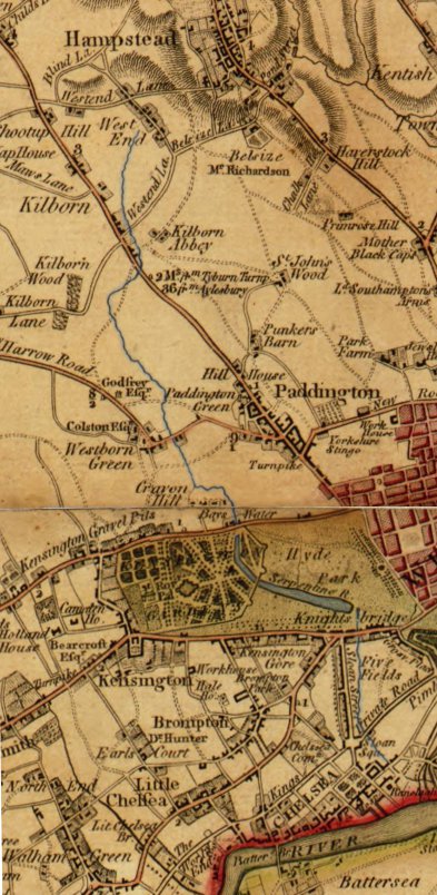
English: Route of the River Westbourne (highlighted in blue) shown between West End (now known as West Hampstead) and the Thames on a 1790 map. |
| Date | |
| Source |
Crop of US Library of Congress scan of 1790 map by Faden, William http://hdl.loc.gov/loc.gmd/g5754l.ct002421 |
| Author | Faden, William |
This image is in the public domain because it is a mere mechanical scan or photocopy of a public domain original, or – from the available evidence – is so similar to such a scan or photocopy that no copyright protection can be expected to arise. The original itself is in the public domain for the following reason:
This tag is designed for use where there may be a need to assert that any enhancements (eg brightness, contrast, colour-matching, sharpening) are in themselves insufficiently creative to generate a new copyright. It can be used where it is unknown whether any enhancements have been made, as well as when the enhancements are clear but insufficient. For known raw unenhanced scans you can use an appropriate {{PD-old}} tag instead. For usage, see Commons:When to use the PD-scan tag.  | ||||
File history
Click on a date/time to view the file as it appeared at that time.
| Date/Time | Thumbnail | Dimensions | User | Comment | |
|---|---|---|---|---|---|
| current | 19:37, 5 February 2010 | | 393 × 804 (108 KB) | Switch199 | {{Information |Description={{en|1=Route of the River Westbourne (highlighted in blue) shown between West End (now known as West Hampstead) and the Thames on a 1790 map.}} |Source=Crop of US Library of Congress scan of 1790 map by Faden, William http://hdl |
File usage
The following file is a duplicate of this file (more details):
- File:Westbourne-route-1790.jpg from a shared repository
The following 2 pages link to this file: