Hemel Hempstead
| Hemel Hempstead | |
| Hertfordshire | |
|---|---|
 High Street, Hemel Hempstead Old Town | |
| Location | |
| Grid reference: | TL056071 |
| Location: | 51°45’9"N, 0°28’9"W |
| Data | |
| Population: | 81,143 |
| Post town: | Hemel Hempstead |
| Postcode: | HP1, HP2, HP3 |
| Dialling code: | 01442 |
| Local Government | |
| Council: | Dacorum |
| Parliamentary constituency: |
Hemel Hempstead |
Hemel Hempstead is a town in Hertfordshire. Though an ancient town, it was developed as a new town from 1946, which utterly transformed it. The population at the 2001 was 81,143, though now estimated at around 89,000.
Hemel Hempstead village has been here since at least the 8th century. The manor of Hemel Hempstead is recorded in the Domesday Book, which some towns now larger, such as Watford, are not. It grew to be a town of some local importance and was granted its town charter by King Henry VIII in 1539. The Old Town still remains and is the prettiest part of town. The biggest change for the town was after Second World War when Hemel Hempstead was developed as a new town, which was built anew next to the Old Town, which was left largely in place.
Pevsner called Hemel Hempstead "The most attractive town in Herts".[1] This however was before the New Town was built on it. Thankfully the new town left in place the parts Pevsener singled out for praise.
The lie of the land

Hemel Hempstead grew up in a shallow chalkland valley at the meeting of the rivers Gade and Bulbourne. It is a natural transport corridor, as roads and latterly railway lines follow the gap carved by the rivers through the Chiltern Hills from London toward the Midlands.
The main railway line between London and the Midlands passes through Apsley and Hemel Hempstead railway stations a mile south of the town centre, as does the Grand Union Canal, each running. These links, as well as the A41 trunk road, follow the course of the River Bulbourne river valley at the western edge of the town. The New Town expansion took place up the valley sides and on to the plateau above the original Old Town. In the 1990s, a motorway-style bypass numbered A41 was built to the south and west of the town across the upland chalk plateau, which does not follow the lie of the land.
Immediately to the east of Hemel Hempstead runs the M1 motorway (while the M25 motorway is a few miles to the south.
To the north and west of the town is open land of mixed farmland and woodland with scattered villages, part of the Chiltern Hills. To the north-west lies Berkhamsted. To the south lies Watford beyond it the beginnings of the conurbation spread out from London. To the east of Hemel Hempstead lies St Albans, an ancient and historic town in contrast to Hemel Hempstead's new and modernist mien.
Possibly the best view over Hemel Hempstead to see its setting in the landscape is from the top of Roughdown Common, a chalk hill to the south of the town, at TL049055.
Churches


The original parish church of the town is St Mary's, in the old town, but now there are many modern churches built in the new town neighbourhoods.
Churches in Hemel Hempstead include:
- Church of England:
- St Mary's, Old Town
- Church of the Resurrection (Grovehill Church)
- Holy Trinity, Leverstock Green
- St Alban's
- St Barnabas
- St Benedict, Bennetts End
- St Francis of Assisi, Hammerfield
- St John's, Boxmoor
- St Mary's, Apsley
- St Paul's, Highfield
- St Stephen's Church, Chaulden
- Baptist:
- Independent evangelical:
- Methodist:
- Pentecostal: New Life Pentecostal Church
- Salvation Army
- Seventh Day Adventist Church
- Society of Friends (Quakers): Friends' Meeting House
- South Hill Church
- United Reformed Church:
- Roman Catholic:
History
Origin of the name
The settlement was called by the name Henamsted or Hean-Hempsted ("High Hempstead"), in Anglo-Saxon times and in the eleventh century by the name of Hemel-Amstede.[2] Other suggestions made for the "Hemel" element is that "Hæmele" was the lost name of a district in the 8th century or the name of the land owner, or that it could mean "broken country".[3][4]
"Hempstead" many mean "home place" or "meadow place".
Hemel Hempstead is named in the Domesday Book of 1086 as "Hamelamesede" and in later centuries it appears as Hamelhamsted.
The town is now known to residents as "Hemel", though before the Second First World Wart was more commonly called "Hempstead".
Early history
Remains of a Roman villa and surrounding farms have been found at Boxmoor and Gadebridge which span the entire period of Roman Britain.
The first recorded mention of the town is the grant of land at Hamaele by Offa, King of Essex, to the Bishop of London in 705. Hemel Hempstead on its present site is mentioned in the Domesday Book of 1086 as a manor named Hamelhamstede, with about 100 inhabitants.
The parish church of St Mary's was built in 1140, and is recognised as one of the finest Norman parish churches in the county. The church features an unusual 200-foot tall spire, added in the 12th century.
After the Norman conquest the land thereabouts was given to Robert, Count of Mortain, the elder half-brother of William the Conqueror, as part of the lands associated with Berkhamsted Castle. The estates passed through many hands over the next few centuries including Thomas Becket in 1162. In 1290 King John of England's grandson, the Earl of Cornwall, gave the manor to the religious order of the Bonhommes when he endowed the monastery at Ashridge. The town remained part of the monastery's estates until the Reformation and the dissolution of the monasteries in 1539.
Modern period
In 1539, Ashridge Priory was dissolved and King Henry VIII granted Hemel Hempstead a royal charter to become a Bailiwick with the right to hold a Thursday market and a fair on Corpus Christi Day. The first Bailiff of Hemel Hempstead was William Stephyns (29 December 1539). The King and Queen, Anne Boleyn, are reputed to have stayed in the town at this time.[5]
Unusually fine mediæval wall paintings from the period between 1470 and 1500 were discovered in some cottages in Piccotts End, very close to Hemel Hempstead in 1953. This same building had been converted into the first cottage hospital providing free medical services by Sir Astley Cooper in 1827.[6]
In 1581, a group of local people acquired lands — now referred to as Box Moor — from the Earl of Leicester to prevent their enclosure. These were transferred to trustees in 1594. These have been used for public grazing and they are administered by the Box Moor Trust.
Hemel's position on the shortest route between London and the industrial Midlands put it on the Sparrows Herne turnpike Toll road in 1762, the Grand Junction Canal in 1795 and the London and Birmingham Railway in 1837.[7] However it remained principally an agricultural market town throughout the 19th century. In the last decades of that century development of houses and villas for London commuters began. The Midland Railway built a branch line connecting to its mainline at Harpenden in 1877. Hemel Hempstead steadily expanded, but only became a borough on 13 July 1898.
During Second World War 90 high explosive bombs dropped on the town by the Luftwaffe. The most major incident was on 10 May 1942 when a stick of bombs demolished houses at Nash Mills killing 8 people. The nearby Dickinson factories which were used to produce munitions and were the target.[8]
New town
After Second World War, in 1946, the government designated Hemel Hempstead as the site of one of its proposed New Towns designed to house the population displaced by the London Blitz, since slums and bombsites were being cleared in London. On 4 February 1947, the Government bought 5,910 acres of land and began work on the "New Town". The first new residents moved in during April 1949, and the town continued its planned expansion through to the end of the 1980s. Hemel grew to its present population of 80,000, with new developments enveloping the original town on all sides. The original part of Hemel is still known as the "Old Town".

Hemel Hempstead was announced as candidate No 3 for a New Town in July 1946, in accordance with the government's "policy for the decentralisation of persons and industry from London". Initially there was much resistance and hostility to the plan from locals, especially when it was revealed that any development would be carried out not by the local council but by a newly appointed government body, the Hemel Hempstead Development Corporation (later amalgamated with similar bodies to form the Commission for New Towns). However, following a public inquiry the following year, the town got the go-ahead. Hemel officially became a New Town on 4 February 1947.
The initial plans for the New Town were drawn up by architect G A Jellicoe. His view of Hemel Hempstead, he said, was “not a city in a garden, but a city in a park.” However, the plans were not well received by most locals. Revised, and less radical plans were drawn up, and the first developments proceeded despite local protests in July 1948. The first area to be developed was Adeyfield. At this time the plans for a double "magic" roundabout at Moor End were first put forward, but in fact it was not until 1973 that the roundabout was opened as it was originally designed. The first houses erected as part of the New Town plan were in Longlands, Adeyfield, and went up in the spring of 1949. The first new residents moved in early 1950.
At this time, work started on building new factories and industrial areas, to avoid the town's becoming a dormitory town. The first factory was erected in 1950 in Maylands Avenue. As building progressed with continuing local opposition, the town was becoming increasingly popular with those moving in from areas of north London. By the end of 1951, there was a waiting list of about 10,000 wishing to move to Hemel Hempstead. The neighbourhoods of Bennett's End, Chaulden and Warner's End were started. The Queen paid a visit shortly after her accession in 1952, and laid a foundation stone for a new church in Adeyfield — one of her first public engagements as Queen. The shopping square she visited is named Queen's Square, and the nearby area has street names commemorating the then-recent conquest of Everest, such as Hilary and Tenzing Road. This conquest is also celebrated in the name of a pub in Warners End – the 'Top of the World'.
The redevelopment of the town centre was started in 1952, with a new centre based on Marlowes south of the old town. This was alongside a green area called the Water Gardens, designed by Jellico, formed by ponding back the River Gade. The old centre of the High Street was to remain largely undeveloped, though the market square closed and was replaced by a much larger one in the new centre. The former private estate of Gadebridge was opened up as a public park. New schools and roads were built to serve the expanding new neighbourhoods. New housing technology such as prefabrication started to be used from the mid-50s, and house building rates increased dramatically. Highfield was the next neighbourhood to be constructed. The M1 motorway opened to the east in 1959, and a new road connecting it to the town was opened.

By 1962, the redevelopment of the new town as originally envisaged was largely complete, though further expansion plans were then put forward. The nearby RAF Bovingdon, which had served as the town's de facto airport, closed at this time, though private flying continued for a further seven years. A campus of West Herts College, the library, new Police station and the Pavilion (theatre and music venue) were all built during the 1960s.
The town seemed to attract its fair share of celebrity openings, with shops and businesses opened by Frankie Vaughan, Benny Hill, Terry-Thomas, and the new cinema was opened by Hollywood star Lauren Bacall. The last of the originally-planned neighbourhoods, Grovehill, began construction in 1967. However, further neighbourhoods of Woodhall Farm and Fields End were later built as part of the extended plans.
Like other first generation new towns, Hemel is divided into residential neighbourhoods, each with their own "village centre" with shops, pubs and services. Each neighbourhood is designed around a few major feeder roads with many smaller cul-de-sacs and crescents, intended to minimise traffic and noise nuisance. In keeping with the optimism of the early postwar years, much of the town features modernist architecture with many unusual and experimental designs for housing. Not all of these have stood the test of time. A significant issue was how to choose names for all the new roads. Many areas of the new town used themes, for example fields, birds, rivers, poets, explorers, politicians and so forth.
The Buncefield explosion

At 6 am on Sunday, 11 December 2005 there was a major explosion in the town at the Hertfordshire Oil Storage Terminal, Buncefield, an industrial estate on the western edge of the town. This was one of the largest explosions ever to occur in the United Kingdom, and was reportedly heard even in Belgium. Over the next few days further subsidiary explosions rocked the town and firemen struggled to subdue the blazing oil depot. Hemel was in the headlines for several weeks as the skies over south-eastern Britain stayed black with the smoke. The incident was described as the biggest of its kind in peacetime Europe.[9]
The Maylands Avenue industrial estate was severely damaged and much of it needed to be demolished. Nearby residential districts of Adeyfield, Woodhall Farm, Highfield and Leverstock Green were also badly damaged and around 300 people were made temporarily homeless. 41 people sustained minor injuries and two were seriously hurt. It is believed that the only reason that no one was killed was because the explosion occurred before dawn on a Sunday.
Commerce, industry and agriculture
Historical

Historically, the area was agricultural and was noted for its rich cereal production. The agricultural journalist William Cobbett noted of Hemel Hempstead in 1822 that "..the land along here is very fine: a red tenacious flinty loam upon a bed of chalk at a yard or two beneath, which, in my opinion, is the very best corn land that we have in England."[10] By the 18th century the grain market in Hemel was one of the largest in the country. In 1797 there were 11 watermills working in the vicinity of the town.[11]
The chalk on which Hemel is largely built has had commercial value and has been mined and exploited to improve farmland and for building from the 18th century. In the Highbarns area, now residential, there was a collapse in 2007 of a section of old chalk workings and geological studies have been undertaken to show the extent of these workings.[12]
In the 19th century, Hemel was a noted brickmaking, paper manufacturing and straw-plaiting centre. In later nineteenth and early twentieth centuries, Hemel was also a noted watercress growing area, supplying a sixteenth of the country's national demand — following development of the New Town, the watercress growing moved to nearby Berkhamsted and Tring. The cress beds were redeveloped as the modern-day Water Gardens.
Joseph Cranstone's engineering company was founded in 1798, and was responsible for much of the early street lighting in the town as well as it first gasworks. It became the Hemel Hempstead Engineering Company and stayed in business until Second World War. In 1867 Cranstone's son built a steam-powered coach which he drove to London, but which was destroyed in a crash on the return journey. A local Boxmoor pub commemorates the event.
In 1803 the first automatic papermaking machinery was developed in Hemel by the Fourdrinier brothers at Frogmore. Paper making expanded in the vicinity in the early nineteenth century and grew into the huge John Dickinson mills in the twentieth.
A traditional employer in the area was also Brock's, manufacturer of fireworks. The factory was a significant employer since well before Second World War, and remained in production until the mid-1970s. The present-day neighbourhood of Woodhall farm was subsequently built on the site.
Industry today
Hemel Hempstead has a mixture of heavy and light engineering companies and has attracted a significant number of information technology and telecommunications sector companies helped by its proximity to London and the UK motorway network. However, (and again in common with many new towns) it has a much narrower business base than established centres, particularly Watford and St Albans.
Sights about the town

Hemel is famous for its "Magic Roundabout", officially called the Moor End roundabout, or The Plough Roundabout from a former adjacent public house. This is an interchange at the end of the town centre (Moor End), where traffic from six routes meet. Traffic is able to circulate in both directions around what appears to be a main central roundabout, with the normal rules applying at each of the six mini-roundabouts encircling this central reservation. The system has coaused confusion and indeed panic amongst the unwary entering it and some worry that some of the traffic flows the 'wrong' way around the inner roundabout, but the central ring is not in fact a roundabout and no roundabout rules apply to it, however loudly certain drivers' car horns protest at the matter. This was the first such circulation system in Britain.
Hemel claims to have the first purpose built multi-storey car park in Britain. Built in 1960 into the side of a hill in the Marlowes shopping district, it features a giant humorous mosaic map of the area by the artist Rowland Emett.
The new town centre is laid out alongside landscaped gardens and water features formed from the River Gade known as the Watergardens designed by GA Jellicoe. The main shopping street, Marlowes, was pedestrianised in the early 1990s.
Hemel also was home of one of the first community based television stations West Herts TV which later became Channel 10.

For many years the lower end of Marlowes featured a distinctive office building built as a bridge-like structure straddling the main road. This building was erected on the site of an earlier railway viaduct carrying the Hemel to Harpenden railway, known as The Nicky Line. When the new town was constructed, this part of the railway was no longer in use and the viaduct demolished. The office building, occupied by BP, was designed to create a similar skyline and effect as the viaduct. In the early 1980s it was discovered that the building was subsiding dangerously and it was subsequently vacated and demolished. Adjacent to BP buildings was a unique double-helix public car park. The lower end of Marlowes was redeveloped into the Riverside shopping complex, which opened on 27 October 2005.
A few feet away, overlooking the 'Magic Roundabout', is Hemel's tallest building; the 22-storey Kodak building. Built as the Kodak company's British headquarters, the tower was vacated in 2005. It was then temporarily reoccupied in 2006 after the Buncefield explosion destroyed Kodak's other Hemel offices. It is now being converted into 434 apartment homes.[13]
The Heathrow airport holding area known as the Bovingdon stack lies just west of the town. On a clear day, at peak times, several circling aircraft can be visible.
The national headquarters of the Boys' Brigade is located at Felden Lodge, near Hemel.
A series of high blue steel arches called the Phoenix Gateway has been installed on the roundabout closest to the Hemel Hempstead junction of the M1 motorway. The aim was to regenerate the town after the Buncefield explosion with a striking piece of commercial art, though no one has satisfactorily explained how that works.

The Old Bell pub in Hemel old town has parts built in 1615 but is on the site of even older inns. It contains some unusual French wallpaper dating back to 1821, which has been cleaned by the Victoria & Albert Museum.
Film and television production
Quatermass 2 used Hemel Hempstead, which was at the time under development, for the fictional, soulless new town of Winerton Flats.[14]
Pie in the Sky (a BBC police drama) was filmed in Hemel. At one point, the site for the restaurant was a florist but is currently a shop selling Dolls' Houses. A nearby restaurant changed its name to Pie in the Sky for a short time while the series was popular.
Birthday Girl (a 1998 film starring Nicole Kidman and Ben Chaplin) features Hemel Hempstead prominently as it was written by a local man. Other scenes were shot in St Albans.
Picture gallery
-
 The Kodak building
 -
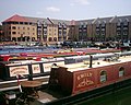 Apsley Lock Marina
 -
 St Mary's Church (1140)


References
- ↑ The Buildings of England: Hertfordshire by Sir Nikolaus Pevsner
- ↑ Origin of the name, Hertfordshire Genealogy, UK. Accessed June 2006.
- ↑ Susan Yaxley
- ↑ "A Key to English Place-Names Hemel Hempstead". Institute for Name-Studies,. School of English Studies, University of Nottingham,. http://www.nottingham.ac.uk/~aezins/kepn/detailpop.php?placeno=4591. Retrieved 8 January 2010.
- ↑ Wright, George Newenham (1836). A new and comprehensive gazetteer, Volume 3. T. Kelly,. p. 382. http://books.google.co.uk/books?id=DiQDAAAAYAAJ&dq=Muresley%20Priory&pg=PA382#v=onepage&q=hempstead&f=false.
- ↑ Dacorum Heritage Trust
- ↑ The Chiltern Canal Corridor Castle Wharf project Berkhamsted. Accessed April 2007
- ↑ Yaxley, page 264
- ↑ "Buncefield tank 'was overflowing'". BBC News. 9 May 2006. http://news.bbc.co.uk/1/hi/uk/4752819.stm. Retrieved 5 June 2007.
- ↑ http://www.visionofbritain.org.uk/text/chap_page.jsp?t_id=Cobbett&c_id=8&p_id=573#pn_8 visionofbritain.org.uk
- ↑ Hemel Trade Directory 1797
- ↑ "About the chalk mines". Dacorum Borough Council. 2008. http://www.dacorum.gov.uk/default.aspx?page=5692. Retrieved 23 November 2008.
- ↑ Council go-ahead for former Kodak site after cut in number of homes Hemel Hempstead Gazette, 4 April 2007. Accessed August 2007
- ↑ Hearn, Marcus; Jonathan Rigby (2003). Quatermass 2. Viewing Notes. London: DD Video. DD06155.
Books
- Edwards, Dennis F.(1994) Hemel Hempstead in old picture postcards European Library, ISBN 90-288-5797-4.
- Hemel Hempstead Directory of 1797 — Early description of the town at Hertfordshire Genealogy. Retrieved November 2009
- Description of Hemel Hempstead (1870–72), John Marius Wilson, Imperial Gazetteer of England and Wales. [1]
- Yaxley, Susan; and others (1973, reprinted 1981). History of Hemel Hempstead. Amplion Press: Hemel Hempstead Local History and Records Society. ISBN 0-9502743-0-5.
- Buteux, Elizabeth (2005). Hemel Hempstead — A History and Celebration. Salisbury, Wiltshire: The Francis Frith Collection. ISBN 1-84589-206-2.
- Hastie, Scott; Fletcher, Lynne (1997). Hemel Hempstead — The Story of New Town Development. Dacorum Borough Council. ISBN 0951153927.
Outside links
- Hemel Web Community web page.
- Hemel on-line Hemel Hempstead community website.
- Photo gallery showing redevelopment of Kodak building
- Hemel Hempstead Local History & Museum Society
- Map of Hemel Hempstead in 1883 from old-maps.co.uk
- Photos of Hemel and surrounding area Indexed by OS grid square at www.geograph.co.uk
- Hemel Hempstead (Pictures and History) on A Guide to Old Hertfordshire
- Berkhamsted and Hemel Hempstead Hockey Club
- Maylands Business Park
- Hemel Hempstead Swimming Club
- Boho Boxmoor The online magazine for Boxmoor and Hemel Hempstead people.
- Snow Centre The Snow Centre Hemel Hempstead.
| ("Wikimedia Commons" has material about Hemel Hempstead) |