Wrexham
| Wrexham Welsh: Wrecsam | |
| Denbighshire | |
|---|---|
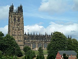 St Giles' Church, Wrexham | |
| Location | |
| Grid reference: | SJ335505 |
| Location: | 53°1’48"N, 2°58’48"W |
| Data | |
| Population: | 42,576 (2001) |
| Post town: | Wrexham |
| Postcode: | LL11-14 |
| Dialling code: | 01978 |
| Local Government | |
| Council: | Wrexham |
| Parliamentary constituency: |
Wrexham |
Wrexham is a city in Denbighshire. It is found to the east of the Welsh mountains, more a continuation of the Midlands plain in the lower Dee Valley close to the county border with Cheshire. As the largest town in North Wales, Wrexham is a major centre of the region's commercial, retail and educational infrastructure. It was granted city status on 1 September 2022 to mark the Queen's Platinum Jubilee.
Contents
The town
Wrexham is not built up upon a major river but is found instead on a relatively flat plateau between the lower Dee Valley and easternmost mountains of Wales. This position enabled the town to grow as a market town as a cross roads between the Midlands and North Wales and later as an industrial hub, thanks to its rich natural reserves of iron ore and coal. Wrexham is also famed for the quality of its underground water reserves, which gave rise to its previous dominance as a major brewing centre.
Three minor rivers runs through parts of the town; the Clywedog, Gwenfro and Alyn.
Originally a market town with surrounding small villages, Wrexham is now coalesced with a number of urban villages to create a conurbation of over 100,000 residents. The Office for National Statistics defines a Wrexham Urban Area which consists of Wrexham Town and some coalesced suburbs, given a population of 63,084 in 2001.
History
The first known settlement at Wrexham was known as Wristleham Castle, a motte and bailey located in what is now known as Erddig Park, established in 1161. King Edward I is on record as having briefly stayed at Wrexham during his expedition to suppress the revolt of Madog ap Llywelyn in 1294. Wrexham was divided into two distinct townships, Wrexham Regis (which was under the control of the King) and Wrexham Abbot (generally the older parts of the town, which originally belonged to Valle Crucis Abbey at nearby Llangollen).
In the 18th century Wrexham was known for its leather industry. There were skinners and tanners in the town. The horns from cattle were used to make such items as combs and buttons. There was also a nail-making industry in Wrexham.
In the mid-18th century Wrexham was no more than a small market town with a population of perhaps 2,000. However, in the late 18th century Wrexham grew rapidly as it became one of the pioneers of the Industrial Revolution.
The Industrial Revolution began in Wrexham in 1762 when the entrepreneur John Wilkinson (1728–1808) known as 'Iron Mad Wilkinson' opened Bersham Ironworks. In 1793 he opened a smelting plant at Brymbo.
Wrexham gained its first newspaper in 1848. The Market Hall was built in 1848, and in 1863 a volunteer fire brigade was founded. Wrexham was also home to a large number of breweries, and tanning became one of Wrexham's main industries. In the mid 19th century Wrexham was important enough to be granted borough status.
Late twentieth century and beyond
In the latter half of the twentieth century, the many coal mines closed first, followed by the brickworks and other industries, and finally Brymbo Steelworks in September 1990. Wrexham faced an economic crisis. Residents were unable to sell their homes to move to areas with better prospects, many caught in a negative equity trap.
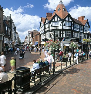
In the 1980s and 1990s, a major dual carriageway, the A483, was built to connect Wrexham with Chester and Shrewsbury, which in turn had connections with other big cities such as Manchester and Liverpool. The town centre was regenerated and attracted a number of high street chains. The Wrexham Industrial Estate, previously used in the Second World War, became the biggest source of change as many manufacturing and technology businesses moved in.
In Wrexham's town centre civic and public areas such as Queens Square, Belle Vue Park and Llwyn Isaf have been regenerated to improve the area dramatically. New shopping areas have been created at Henblas Square and Island Green with the newest development at Eagles Meadow. The development increases Wrexham's retail area by over 400,000 square feet and houses retail outlets, bars, restaurants, cinema, a bowling alley and new apartments. It includes public areas and a bridge to connect the development with the old High Street. Debenhams and Marks and Spencers are the largest of retailers in this new development. The development has had a mixed reaction from local people,[1] with complaints about the design, location, and the quality of the construction.
Wrexham is undergoing a substantial period of population growth and house price, once depressed, have risen faster than in neighbouring areas.
Landmarks
A number of visitor attractions can be found in the town or within a short drive from the centre. Among the most popular are:
- Bangor-on-Dee racecourse
- Clywedog Valley - The power behind the industrial revolution in Wrexham, a number of good heritage attractions: (Minera Leadmines, Nant Mill and Bersham Ironworks) in a peaceful valley with good walks (BBC's 20 hidden gems in 2007[2])
 Erddig Hall - National Trust property and park (voted the UK's best historical house and 8th most popular historic site - 2007)
- Historic town centre buildings (Horse & Jockey pub, thatched roof pub, Regent Street)
- Pontcysyllte Aqueduct
- Racecourse Ground, home of Wrexham F.C.
- St Giles Church – Knwn as one of the "Seven Wonders of Wales"
- Techniquest Glyndŵr - Science discovery centre
- Wrexham Museum
Economy
Wrexham's economy has been transformed in the past twenty years from one dominated by heavy and traditional industry into a major high-tech manufacturing, technology and services hub. Wrexham Industrial Estate is Britain's second-largest industrial park and among the largest in Europe. The remainder of the industrial parks are located around the A483 corridor to the west of the town.
Wrexham has held on to a substantial manufacturing base after facing stiff competition from growing eastern European and Asian economies. Approximately 25% of jobs in Wrexham are in the manufacturing sector, with a growing number in service, financial and technology industries.
In 2007, the town was ranked fifth in the UK for business start-up success, higher than most larger UK towns and cities.[3] The Wrexham local government district as a whole has an economic activity rate of 79.5 percent, which is above both the Wales and Great Britain averages.
In the last five years high land prices have led to large apartment blocks being built in and around the town. Scarcity of town centre land has led to numerous housing estates being built in the surrounding villages on the outskirts, notably in Brymbo, Gwersyllt and Rhostyllen.
Culture
Arts
Wrexham hosted the National Eisteddfod in 1888, 1912, 1933 and 1977, as well as an unofficial National Eisteddfod event in 1876. The National Eisteddfod returned to the area in 2011, when Wales' leading festival was held on the land of Lower Berse Farm from 30 July - 6 August.
Wrexham has a number of theatres, including the Grove Park Theatre on Vicarage Hill, the Riverside Studio Theatre at Wrexham Musical Theatre Society on Salop Road, and the Yale Studio theatre close to Llwyn Isaf. Local theatre group, Tip Top Productions [1] also present the annual Christmas Pantomime at The Stiwt Theatre in nearby Rhosllanerchrugog. The main Arts centre is at Wrexham Library, with others at Glyndŵr University in Plas Coch and Yale College. There is a multi-screen Odeon cinema in the Eagles Meadow development. The nearby town of Llangollen holds the International Musical Eisteddfod every July.
Science
Every March the town hosts the Wrexham Science Festival. Over 9,000 visitors attended events in 2007, making the event one of the biggest of its kind.
Wrexham is also home to a branch of Techniquest, known as Techniquest Glyndŵr. The science discovery centre is situated within Glyndŵr University's Plas Coch campus.
Parks and open spaces
Wrexham has two main town parks, these being Bellevue Park and Acton Park, and open parkland at Erddig. With the rapid development of the town in the 19th century, the need for a formal park for the growing population was identified. However it was not until 1906 that the location for the new park was agreed upon. The 'Parciau' or Bellevue Park as it became known, was built alongside the old cemetery on Ruabon Road. The park was designed to commemorate the Jubilee year of the Incorporation of Wrexham.
Bellevue Park
During the 1970s Bellevue Park was neglected and many of the amenities were in a poor state of repair. A major project was undertaken to refurbish the park back to its original splendour. This was funded by the Heritage Lottery Fund, Urban Parks Project, Welsh Development Agency, and the European Regional Development Fund. The park reopened in June 2000. It now boasts children's play areas, a bowling green which is home to the Parciau Bowling Club, tennis and basketball courts, an original Edwardian bandstand set in an amphitheatre, and a jogging route for walkers and joggers. The park itself has many walkways through mature tree-lined avenues as well as affording some magnificent views of the Parish Church. The park is well lit and has a number of CCTV cameras installed to deter antisocial behaviour.
Bellevue Park has once again regained its popularity with the people of Wrexham. Throughout the summer months social events take place, such as music concerts for all tastes and 'Fun days' for children.
Acton Park
Acton Park was originally the landscaped grounds of Acton Hall. It was originally laid out in 1785 by James Wyatt on the instructions of the owner Sir Foster Cunliffe. Over the years the Estate passed through several owners. In 1947 Wrexham Council was given the Hall and Park by the then owner Alderman William Aston. A section of Acton Park was sold for housing development in the 1970s. The surviving area now covers approximately 55 acres.
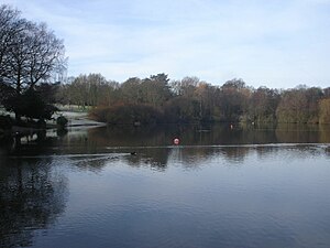
Acton Park features a bowling green, tennis courts, a children's play area, Japanese-style garden and a large lake which has attracted diverse wildlife. The general layout of the park has remained unchanged since it was laid out in the 18th century and now boasts many mature trees.
Llwyn Isaf
Llwyn Isaf, situated alongside Wrexham Guildhall, is a popular green area within the town centre. The green was originally the landscaped grounds of a mansion house known as Llwyn Isaf. It now lies at the centre of Wrexham's civic centre just off Queens Square.
Erddig
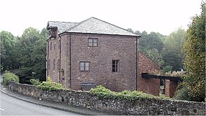
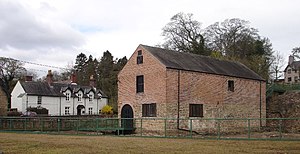
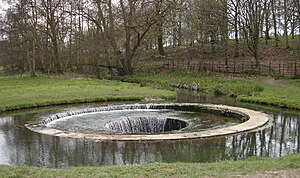
![]() Erddig Park lies two miles south of the town centre where the town meets the Clywedog Valley. The park is owned and managed by the National Trust, and is home to Erddig Hall and its formal gardens. The Park is also home to a number of notable historic features. These include a hydraulic ram known as the 'Cup and Saucer' which is used to pump water from the park to Erddig Hall, and the remains of Wristleham motte and bailey which is thought to be the beginnings of Wrexham as a town in the 12th century.
Erddig Park lies two miles south of the town centre where the town meets the Clywedog Valley. The park is owned and managed by the National Trust, and is home to Erddig Hall and its formal gardens. The Park is also home to a number of notable historic features. These include a hydraulic ram known as the 'Cup and Saucer' which is used to pump water from the park to Erddig Hall, and the remains of Wristleham motte and bailey which is thought to be the beginnings of Wrexham as a town in the 12th century.
Heritage
Wrexham's former police station on Regent Street, originally the barracks for the Royal Denbighshire Militia, is now home to Wrexham Museum. The Museum has two galleries devoted to the history of the town and its surrounding communities. There is also a programme of temporary exhibitions, including an exhibition featuring the Mold Cape, the first time the Bronze Age treasure had returned to Denbighshire from the British Museum since its discovery in 1833. Just to the west of the town, Bersham Heritage Centre and Ironworks tell the story of John Wilkinson, the 'Iron Mad' pioneer of the Industrial Revolution. At the top end of the Clywedog Valley, about ten minutes' drive from Wrexham, Minera Lead Mines are the remains of the profitable lead industry that dates back to prehistoric times.
To the east of Wrexham, there are the remains of Holt Castle. The castle and the nearby late mediæval bridge were the scene of constant skirmishes during the Civil War in the 17th century. The River Dee in this area is deep and wide. The bridge at Holt was the first crossing point south of the city of Chester and hence was of major strategic importance.
Just two miles south of Wrexham town centre, Erddig, the National Trust property, was home to the Yorke family until 1973. Its last resident, Philip Yorke, handed over a house in need of restoration as years of subsidence caused by the workings of Bersham Colliery had caused a lot of damage.
One thing Wrexham has always been famous for is beer. In the mid to late 19th century Wrexham had over 35 breweries, and grew a proud tradition of brewing both ale and lager. In 1882 German immigrants set up Britain's first lager brewery under the name of Wrexham Lager. In 2000 the Wrexham Lager Brewery was the last one to close. A number of the original brewery buildings remain, most notably Wrexham Lager on Central Road (offices), Soames Brewery on Yorke Street (Nags Head) and Border Brewery on Tuttle Street (converted apartments).
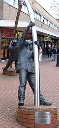
Wrexham's mining heritage is nearly all gone. Most former mines have been converted into industrial and business parks - one such development at Bersham Colliery has the last surviving head gear in the north Wales coalfield. Just off the A483, on the edge of Wrexham, the Gresford Disaster Memorial stands witness to the 261 miners, two rescuemen and one surface worker killed by a series of explosions in the Gresford colliery in 1934.
Military heritage
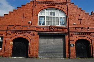
Wrexham has historically been home to a major barracks known locally as the hightown barracks, which was headquarters to the Royal Welch Fusiliers until it merged with the Royal Welsh as 1st Battalion in 2006 and relocated to nearby Chester. The Fusiliers also had a large drill hall on Poyser Street on the opposite side of town.
An airbase, RAF Wrexham, was used to defend the industrial centres of Liverpool and the Wirral, as well as Wrexham's Royal Ordnance Factory, ROF Wrexham from air attack during Second World War, and the airfield itself had been used for training purposes since 1917. There were a few incidents in its many years of operation, and care is being taken in construction of a new road around the site to not disturb any aircraft remains.[4] The airbase was closed in the years after the war, and the land has since been used as a quarry for the Tarmac company. While the terms of the lease mandate the land must be returned to its previous state once finished with, it is anticipated this is a pre-airfield state.[5]
Borras bunker
Between 1962 and 1992 there was a hardened nuclear bunker, built at Borras for No 17 Group Royal Observer Corps North Wales, who provided the field force in Western Area of the United Kingdom Warning and Monitoring Organisation and would have sounded the four minute warning alarm in the event of war and warned the population of Wrexham in the event of approaching radioactive fallout.[6] The building was manned by up to 120 volunteers who trained on a weekly basis and wore a Royal Air Force-style uniform. After the break up of the communist bloc in 1989, the Corps was disbanded between September 1991 and December 1995. However, the nuclear bunker still stands at Borras Park. Between the ROC vacating the premises in September 1991 and its new use as a recording studio around 1993, the building was under preparation for use as the Home Office North Wales Regional Government Headquarters.
Churches
- Church in Wales: St Giles (see below)
- Baptist
- Methodist: Wrexham Methodist church (built in 1971 on the site of the former Brynyfynnon Chapel)
- Roman Catholic: St Mary's Cathedral
- Salvation Army
The Parish Church of St Giles
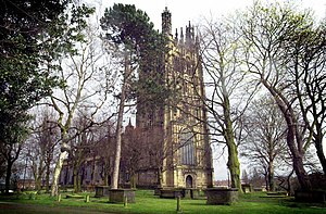
St Giles is the Parish Church of Wrexham and is considered to be the greatest mediæval church in Wales.[7] It includes a colourful ceiling of flying musical angels, two early eagle lecterns, a window by the artist Edward Burne-Jones and the Royal Welch Fusiliers chapel. In the graveyard is the tomb of Elihu Yale who was the benefactor of Yale University in New Haven, Connecticut in America and after whom Yale College Wrexham is named. As a tribute to Yale and his resting place, a scaled down replica of the church tower, known as 'Wrexham Tower' was constructed at Yale University. The tower appears in an 18th-century rhyme, as one of the "Seven Wonders of Wales".
In the past, Wrexham had a church with a spire much taller than the St Giles steeple. This church was dedicated and named after St Mark, but this was demolished as the building's foundations were in danger of collapse. A multi-storey car park named "St Mark's" was erected on the site.
References
- ↑ BBC North East Wales http://www.bbc.co.uk/wales/northeast/sites/wrexham_town/pages/eaglesmeadow.shtml
- ↑ BBC: Your 20 Hidden Tourist Gems
- ↑ Latest Wrexham News - Wrexham entrepreneurs lead the way
- ↑ Wrexham Industrial Estate Environmental statement North
- ↑ Borras Quarry Landscape assessment, 2002 Retrieved June 20, 2010
- ↑ "UKWMO Group Controls". Subbrit.org.uk. http://www.subbrit.org.uk/rsg/roc/group_hq.html. Retrieved 2008-03-17.
- ↑ Church Network
Outside links
- wrexhammusic.co.uk - online hub for music in Wrexham
- Wrexham Arts - a online hub for arts, culture and entertainment in Wrexham
- Local History — Wrexham (BBC)
- Wrexham Today - Wrexham portal
- 360 Degree Panoramic View of Queens Square (BBC) (Java required)
- Evening Leader
- Francis Frith Historic Photos of Wrexham (mainly from 1895)
- The Clwyd-Powys Archaeological Trust
- Wrexham Musical Theatre Trust
- Calon FM - Wrexham Community Radio
| Cities in the United Kingdom |
|---|
|
Aberdeen • Armagh • Bangor (Caernarfonshire) • Bangor (County Down) • Bath • Belfast • Birmingham • Bradford • Brighton and Hove • Bristol • Cambridge • Canterbury • Cardiff • Carlisle • Chelmsford • Chester • Chichester • Colchester • Coventry • Derby • Doncaster • Dundee • Dunfermline • Durham • Ely • Edinburgh • Exeter • Glasgow • Gloucester • Hereford • Inverness • Kingston upon Hull • Lancaster • Leeds • Leicester • Lichfield • Lincoln • Lisburn • Liverpool • City of London • Londonderry • Manchester • Milton Keynes • Newcastle upon Tyne • Newport • Newry • Norwich • Nottingham • Oxford • Perth • Peterborough • Plymouth • Portsmouth • Preston • Ripon • Rochester • Salford • Salisbury • Sheffield • Southampton • St Albans • St Asaph • St David's • Southend-on-Sea • Stirling • Stoke-on-Trent • Sunderland • Swansea • Truro • Wakefield • Wells • Westminster • Winchester • Wolverhampton • Worcester • Wrexham • York |
