Difference between revisions of "Dduallt"
From Wikishire
| (2 intermediate revisions by 2 users not shown) | |||
| Line 1: | Line 1: | ||
{{Infobox hill | {{Infobox hill | ||
| − | | name = Dduallt | + | |name=Dduallt |
| − | | picture = Dduallt - geograph.org.uk - 6803.jpg | + | |picture=Dduallt - geograph.org.uk - 6803.jpg |
| − | | | + | |picture caption = The eastern face of Dduallt |
| − | + | |county=Merionethshire | |
| − | | county = Merionethshire | + | |range=Cambrian Mountains |
| − | | range = | + | |os grid ref=SH810273 |
| − | | os grid ref = SH810273 | + | |latitude=52.830198 |
| − | | height= 2,172 feet | + | |longitude=-3.765779 |
| + | |height=2,172 feet | ||
}} | }} | ||
| − | '''Dduallt'''is a mountain in [[Merionethshire]]. It is the sister peak of [[Rhobell Fawr]]. Its name is from the Welsh language for 'Black hill'. | + | '''Dduallt''' is a mountain in [[Merionethshire]]. It is the sister peak of [[Rhobell Fawr]]. Its name is from the Welsh language for 'Black hill'. |
| − | + | The mountain stands to the north of the A494 between [[Dolgellau]] and [[Llanuwchllyn]]. Its eastern slopes are the source of the [[River Dee]].<ref>Nuttall, John & Anne (1999). The Mountains of England & Wales - Volume 1: Wales (2nd edition ed.). Milnthorpe: Cicerone. ISBN 1-85284-304-7.</ref> | |
| + | |||
| + | ==Outside links== | ||
| + | *Location map: {{wmap|52.830198|-3.765779|zoom=14}} | ||
| + | *{{geograph|2798059|Dduallt}} | ||
==References== | ==References== | ||
{{Reflist}} | {{Reflist}} | ||
| − | |||
| − | |||
| − | |||
{{stub}} | {{stub}} | ||
| − | |||
| − | |||
Latest revision as of 11:10, 28 August 2018
| Dduallt | |||
| Merionethshire | |||
|---|---|---|---|
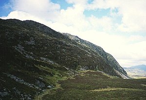
 The eastern face of Dduallt | |||
| Range: | Cambrian Mountains | ||
| Summit: | 2,172 feet SH810273 52°49’49"N, 3°45’57"W | ||
Dduallt is a mountain in Merionethshire. It is the sister peak of Rhobell Fawr. Its name is from the Welsh language for 'Black hill'.
The mountain stands to the north of the A494 between Dolgellau and Llanuwchllyn. Its eastern slopes are the source of the River Dee.[1]
Outside links
References
- ↑ Nuttall, John & Anne (1999). The Mountains of England & Wales - Volume 1: Wales (2nd edition ed.). Milnthorpe: Cicerone. ISBN 1-85284-304-7.
This Mountain or hill article is a stub: help to improve Wikishire by building it up.