Roman roads
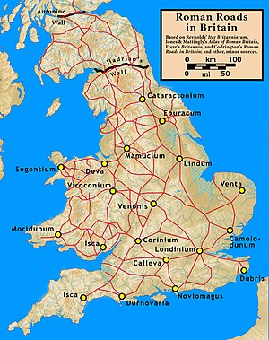
The Roman roads of Great Britain were highways of the Roman Empire during the four centuries that Britannia was a Roman province. During the four centuries of Roman occupation, between AD 43 and approximately 410, the Roman Army constructed and maintained 2,000 miles of paved trunk roads throughout those parts of Britain thery controlled. Most of the known network was complete by AD 180.
The primary function of the road network, at least initially, was to allow the rapid movement of troops and military supplies. It also provided vital infrastructure for commerce and trade. Although many of the roads remained in use as core trunk routes for centuries after the Romans withdrew from Britain, the systematic construction of paved highways did not resume in England until the early 18th century. The Roman-road network was the only nationally-managed highway system which Britain had ever known until the establishment of the Ministry of Transport in the early 20th century.
Prehistory and history
There were long-distance routes before the Roman conquest, but not paved roads; before the invasion of Claudius, the roads of Britain were unpaved trackway. Some of these long-distance routes may have existed for centuries, following elevated ridge lines across hills, most famously the Icknield Way, and some indeed were reused by the Romans. Nevertheless, some recent research has shown evidence of road engineering by Britons during the first century BC.[1]
Beginning in 43 AD, the Romans quickly created a national road network. Key locations, strategic and administrative, were connected by the most direct routes possible. Main roads were gravel or paved]], bridges built in stone or wood, and inns built where travellers or military units could stop and rest. The roads' impermeable design permitted travel in all seasons and weather.
Following the withdrawal of the Romans, conventionally set at 410, the road system was not systematically maintained and slowly fell into disrepair. Parts of the network were retained and continued to form major routes in the Anglo-Saxon period, whilst other large sections were abandoned and lost. Such English names as Watling Street and Fosse Way were given to the routes in the Anglo-Saxon period. The word "street" in modern English is the Old English stræt, used to describe the Roman roads; the word is from the Latin stratum.
References
- ↑ Morris, Steven (15 March 2011). "Britannia Superior: Why Roman roads may not be quite as Roman as we think". The Guardian. http://www.guardian.co.uk/science/2011/mar/15/britannia-roman-roads-iron-age. Retrieved 16 March 2011.
