File:Parsons Tower, Ford - geograph.org.uk - 358625.jpg
From Wikishire
No higher resolution available.
Parsons_Tower,_Ford_-_geograph.org.uk_-_358625.jpg (640 × 480 pixels, file size: 114 KB, MIME type: image/jpeg)
Summary
| Description |
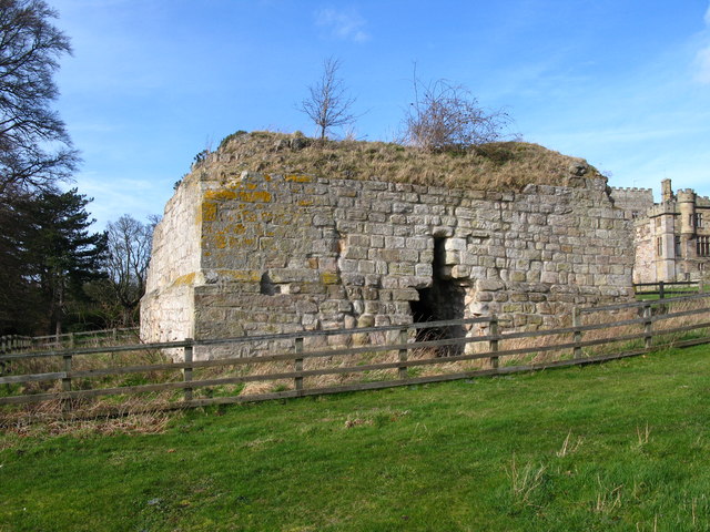
English: Parsons Tower, Ford Parsons Tower is a 14th century stone tower house to the south-west of Ford Castle. It was the home of the resident parson. The square tower shows traces of later attached buildings in its stonework. It now stands to the height of the first floor and the basement is covered by a barrel vault, enclosing a single chamber. It was damaged in 1513 and repaired in 1541 to make a vicar's pele. |
| Date | |
| Source | From geograph.org.uk |
| Author | Lisa Jarvis |
| Attribution (required by the license) | Lisa Jarvis / Parsons Tower, Ford / |
| Camera location | | View this and other nearby images on: OpenStreetMap |
|---|
_heading:337.00&language=en)
| Object location | | View this and other nearby images on: OpenStreetMap |
|---|
_heading:337.00&language=en)
Licensing

|
This image was taken from the Geograph project collection. See this photograph's page on the Geograph website for the photographer's contact details. The copyright on this image is owned by Lisa Jarvis and is licensed for reuse under the Creative Commons Attribution-ShareAlike 2.0 license.
|
This file is licensed under the Creative Commons Attribution-Share Alike 2.0 Generic license.
Attribution: Lisa Jarvis
- You are free:
- to share – to copy, distribute and transmit the work
- to remix – to adapt the work
- Under the following conditions:
- attribution – You must give appropriate credit, provide a link to the license, and indicate if changes were made. You may do so in any reasonable manner, but not in any way that suggests the licensor endorses you or your use.
- share alike – If you remix, transform, or build upon the material, you must distribute your contributions under the same or compatible license as the original.
File history
Click on a date/time to view the file as it appeared at that time.
| Date/Time | Thumbnail | Dimensions | User | Comment | |
|---|---|---|---|---|---|
| current | 19:34, 2 January 2011 | | 640 × 480 (114 KB) | GeographBot | == {{int:filedesc}} == {{Information |description={{en|1=Parsons Tower, Ford Parsons Tower is a 14th century stone tower house to the south-west of Ford Castle. It was the home of the resident parson. The square tower shows traces of later attached buildi |
File usage
The following file is a duplicate of this file (more details):
- File:Parsons Tower, Ford - geograph.org.uk - 358625.jpg from a shared repository
The following page links to this file: