Barony and Castle of Giffen
| Giffen Castle | |
|
Ayrshire | |
|---|---|
 Giffen Castle in 1835 | |
| Location | |
| Grid reference: | NS377507 |
| Location: | 55°43’22"N, 4°35’6"W |
| History | |
| Built 15th century | |
| Information | |
| Condition: | No clear remains |
| Owned by: | Giffen Mains Farm |
The Barony of Giffen and its associated 15th-century castle were in the parish of Beith in Ayrshire. The site may be spelled Giffen or Giffin and lay within the Lordship of Giffin, which included the Baronies of Giffen, Trearne, Hessilhead, Broadstone, Roughwood and Ramshead; valued at £3788 9s 10d.[1] The Barony of Giffen comprised a number of properties, including Greenhills, Thirdpart, Drumbuie, Nettlehirst and Balgray, covering about half of the parish of Beith.[2] Giffen was a hundred merk land, separated from the Barony of Beith, a forty-pound land, by the Powgree Burn which rises on Cuff hill.[3] The Lugton Water or the Bungle Burn running through Burnhouse may have been the Giffen barony boundary with that of the adjacent barony and lands of Aiket castle.
Giffen has a recorded history that covers many of familiar aspects of a feudal barony, including the possession of a moot hill or justice hill, here represented by 'Greenhills', as well as a thirled mill and a 'gathering place' known as the 'Borestone'. Other features such as the old chapel and the holy well add to the expected features, most of which no longer survive.
Contents
The history of Giffen Castle
The 40-foot high tower castle of Giffen lay near to the existing Mains of Giffen site on the 180 ft high summit of a whinstone trap ridge (NS37735072). MacGibbon and Ross[4] suggest that Giffen Castle was built in the 15th-century, although the 13th-century (1233)[5] land grant to Walter de Mulcaster and the prior existence of a chapel, suggest that a defensive structure of some sort was present at that date. At the time of Pont's survey (J Dobie 1876), it was a tower 30 feet square, 40 feet high, with walls six feet thick. It fell into disrepair soon after 1726 and finally collapsed in 1838.
The castle was acquired by Sir John Anstruther in the early 18th century and he is responsible for allowing it to become a ruin, together with the associated Giffen farm. The sundial originally in the Giffen castle garden was sold and was moved eventually to Crummock house, Beith, now demolished. This sundial had its horizontal plane divided by volutes, between which a lion's head alternates with a rose; it was made in 1719 and repaired in 1810. Local farm houses were built using stone from the front wall of the castle, which was consequently entirely removed. Above the entrance, with its strong iron door,[6] there had been a carving of a man shooting with a crossbow at what has been called a wild boar. It is not unlikely that this commemorates a feat of bold hunting by a member of the family of Giffen. A similar carving at Linton parish church commemorates just such a feat, for which William the Lion knighted the bowman and bestowed upon him the lands and barony of Linton.[4]
In 1837 the castle's south wall fell[7] and finally on 12 April 1838, during the silence of the night, the north and east walls of the old castle fell leaving little more than a disorderly heap of stones. The adjacent Mains of Giffen farm had been feued by Anstruther to Robert Craig in 1726. John King of 'Giffin Miln' built his house using stone from the castle and this is probably how the old carvings came to be incorporated into the walls of this building. The doorjambs are also said to have come from the old castle. Thomas Craig, grandson of Robert, passed on the feu to Thomas White in 1816, during whose possession the castle met its final fall.


In August 1956 the Ordnance Survey reported that the remains of Giffen Castle now consist of three fragments of rubble masonry, the largest portion measuring 4.0 m long by 2.0 m thick and 1.9 m high. The remainder of the castle was demolished in about 1920 when the adjoining quarry was dug.
In June 1983 the Ordnance Survey visited the site again and stated that there are no remains of the castle in situ. The three fragments of masonry are in fact large tumbled blocks, and together with a mass of loose shaped stone, also from the castle, form a garden rockery. A marriage stone lintel above the doorway of the adjacent Mains house is inscribed RC MC 1758. This appears contemporaneous to the single story house and of doubtful association with the old castle.
Mr. Robert King, the farmer of the lands near Giffen castle reported in the 1890s that when digging drains to the north-east of the castle he came across a large number of bones which tradition says were there as a result of a battle fought by the lord of the castle, his retainers and an attacking party. The bones were in a hollow to the west of the castle, and between it and the high ground on which the castle and hamlet of Giffen stood.[8] Metal detectorists found a number of musket balls in this area.
Giffen House


William Patrick Esq. of Roughwood and Woodside, a descendant of the ancient family of the Ayrshire Patricks, purchased the mid-superiority of Giffen from the Earl of Eglinton in 1855 and also acquired the dominum utile of much of the barony. In 1861 his grandnephew, Henry Gardiner Patrick, son of John Shedden Patrick of Trearne and Woodside, succeeded to the property and built a large and handsome mansion-house in the Scottish Baronial style on the lands of Bankhead farm, a little over two miles from the old Castle of Giffen.[5][9]
Giffen Castle and Stables was designed in 1869 by architects Andrew Heiton (junior), John Murray Robertson, and Thomas Arthur Heiton. The building was classified under the category of "Castle" and is a Historic Scotland 'B Listed' building.[10]
Giffen House had been completed for about 50 years, when the owner, Mr. Patrick, died in August 1922, leaving the Estate to a nephew in Edinburgh. The nephew sold the estate, which extended to about 885½ acres, chiefly arable and enclosed land, but it included about 54½ acres of woodland and wooded policies. It contained 4 public rooms, 6 family bedrooms, 3 dressing rooms, day and night nurseries, bathroom, 6 servants' bedrooms, and ample kitchen and domestic accommodation making 35 rooms in all. The offices included excellent stabling, garage, lodge, and coachman's house.
The Castletoun of Giffen
General Roy's survey of 1747 - 55 spells the name as 'Giffin' and indicates a cluster of buildings; a hamlet, on the southern side of the castle.
The Chapels and the Chapel Well
The chapel and well lay near to Giffen castle according to John Smith,[11] however another chapel and well dedicated to St Bridget existed at Trearne on a low hill, with an associated burial ground and a nook in which was set a carving of two figures, possibly a cat and a rabbit, measuring 25 inches by 15 inches.[12] The chapel ruins at Trearne were destroyed by quarrying in comparatively recent times. The quarry workers started coming across graves as they worked closer to the chapel and oddly the bodies were found buried face down.[13]
In the 12th-century, the Laird, William de Nenham had granted land to the monastery of Dryburgh and a chapel was built to the south-east of the castle, possibly next to the well which is still marked on the 2001 OS map, known locally as the Chapel Well.[14] William's son Richard granted more land at this site, however his brother Alexander inherited and wished for his chapel to be held by the monastery of Kilwinning and not Dryburgh. To achieve this end he gave land for a site at Trearne, next to St. Bridget's chapel which had previously been granted to the Monks of Dryburgh.
The Barony chapel at Trearne was for the souls of Richard de Morville, William de Morville, Roland of Galloway, Elen de Morville and of their heirs, as well as that of Walter de Mulcaster, his ancestors and his successors.[14] The chapel at Giffen was likely to have been for the same overlords or superiors, but also for Alexander de Nenham, his ancestors and his successors.
This situation of excambied or exchanged lands has led to some confusion in that three chapels appear to have existed at one time within the Lordship of Giffen, not two as is usually stated.[15] The other chapel was in Beith.

The Giffen mill complex and Giffen brae; the road to Mains of Giffen and Burnhouse
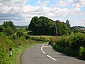
The woodland denotes the site of old Giffen castle. See the 1860s print above as a comparison.
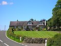
Mains of Giffen, partly built with stones from Giffen castle

Mains of Giffen with the site of the old 'castletoun' to the left, and the road to Barrmill from Burnhouse


Giffen Mill

The old feudal or barony mill, also known as Barmill, Barrmill or Baroil is at NS36995133. The remains visible today are early 19th-century, probably rebuilt on an old site, when grain prices were driven up by the Napoleonic Wars. The external stair led to the kiln for drying the corn before it was ground.[16] It was a three-storey, four-bay rubble building on a rectangular plan, now gutted and the upper part used as a store until recently. A small dovecot was located in the upper angle of the gable end above the miller's house yard. The mid-18th century substantial miller's house is still occupied and is in good condition. On General Roy's survey of 1747 - 55 Giffin Mill is present with a cluster of buildings nearby. The mill pond and lade are clearly marked on the 1858 OS map and a sand pit is marked nearby. The 1923 - 4 the OS map no longer marks the mill or its lade and mill pond.
Giffen would have been the thirled mill of the barony, thirlage being the feudal law by which the laird of Giffen could force all those vassals or suckeners living on his lands to bring their grain to his mill to be ground. Additionally the suckeners had to carry out repairs on the mill, maintain the lade and weir as well as conveying new millstones to the site.[17][18]
The miller's house had two carved stones from Giffen Castle built into its walls and a further one built into the gable end wall of the mill itself. In 2006 / 2007 the miller's house was renovated, however the other carved stones were not found during the re-roughcasting; they had been on the front.[19] The grandfather of the present owner had the stones chipped off; they were located either side of the main entrance door. The 'Eagle' on the mill gable end is still in situ (see photograph).

The remains of the waterwheel inside the mill extension

Inside the mill looking towards Greenhill

The main mill machinery

Carvings at the mill from the old castle


The 'Eagle' from Giffen Castle, now in the lower gable wall of Giffen mill

Giffen mill and Miller's house. The doorway is said to have come from the old castle.

Giffen Mill and the old Miller's house from the village of Barrmill

The Dusk Water which powered Giffen Mill


Giffen, Beith, or Nettlehirst limeworks
Giffen Limeworks dated from the mid to late 19th-century and later. They were probably the last traditional limeworks to work in Scotland, closing in 1972. A substantial amount remained, the kilns being essentially intact in 2009, with a bank of two single-draw rubble kilns, reinforced with buttresses and with old rails, and heightened in brick. Progressive demolition has been taking place since 2009. Covered conveyors linked the segmental-arched draw holes with a wood-framed, corrugated-iron crushing and bagging mill. The works were at map reference: NS 3645 5073.
Limekilns


Limekilns are a common feature of farms in the area, such as Thirdpart, Foreside, Nettlehirst and the Greenhills hamlet; the necessary limestone was quarried extensively in the neighbourhood. Limekilns came into regular use about the 18th-century. Large limestone blocks were used for building but the smaller pieces were burnt, using coal dug in the parish[20] to produce lime which was a useful commodity in various ways: it could be spread on the fields to reduce acidity, for lime-mortar in buildings or for lime-washing on farm buildings and was even regarded as cleansing agent.

The old school site at Greenhills

The line and old signal running towards Giffen station

The course of the old 'Hillhead Railway' from Barkip Junction to Broadstone limestone quarry

The Giffin House main entrance, near Auchenmade


The Old Station Inn in Barrmill

Barrmill crossroads, with hotel and shop

Barrmill's Community Hall

Barrmill's millennium garden

Barrmill's mainstreet with the railway bridge, looking towards Greenhills

Barrmill's park


Local history and traditions


The Ayrshire Directory 1837 by Pigot & Co comments, a year before Giffen Castle collapsed, on ...the stately ruined castle of the Montgomeries. The same publication also lists a Land Surveyor named John Giffin and a John Giffen who was associated with the schools.
A small hoard of 16th-century coins was found on 7 March 1958 by A Wilson and A M Raeside when ploughing 250.0 yards (228.6 m) southwest of Mains of Giffen. The coins had been placed in the bronze container of a small nest of weights, 1½ inches in diameter. This box, and 12 of the 19 coins were retained by the National Museum of Antiquities of Scotland (NMAS). All Scottish, they dated between 1558 (a billon "nonsunt" of Mary) and 1574 (a half-merk[21] of James VI). The coins are mostly half and quarter-merks of James VI; they were probably hidden in the later 1570s.[22]

Records show that a William Giffen was appointed councillor in 1710 at Corsehill. Trearne house was used by a small boarding school called Gresham House until it was demolished in 1954.
The Lugton Ridges were part of the Barony of Giffen and one was also known as Deepstone.[23]
The Dusk Water which powered Giffen Mill joins the River Garnock at Dalgarven and one of Ayrshire's most interesting natural curiosities, Cleeves Cove cave system is situated in the Dusk Glen, downstream of Giffen, near Cleeves farm.

In the 1830s 40 locals died from cholera and were buried in a triangular plot at the base of Jamesill Hill. The tradition is that the disease was passed on from a group of gipsies that local boys had gone out to meet.[24]
Mossend Farm survives as ruins in a copse next to a whinstone quarry across the lane from the old Dustyridge Farm.
Outside links
References
- ↑ Robertson, George (1820). A Topographical Description of Ayrshire: More particularly of Cunninghame, etc .... Irvine: Cunninghame Press. p. 285.
- ↑ Love, Dane (2005). Lost Ayrshire. Ayrshire's lost Architectural Heritage. Pub. Birlinn. ISBN 1-84158-356-1. p. 12 - 13.
- ↑ Dobie, James (1876). Pont's Cunninghame topographized 1604–1608 with continuations and illustrative notices (1876). Pub. John Tweed. P. 85.
- ↑ 4.0 4.1 MacGibbon, T. and Ross, D. (1887–92). The castellated and domestic architecture of Scotland from the twelfth to the eighteenth centuries, 5v, Edinburgh.
- ↑ 5.0 5.1 Millar, A.H. (1885) The Castles and Mansions of Ayrshire. Reprinted by The Grimsay Press. 2000. ISBN 1-84530-019-X. P.84 & 85.
- ↑ Jamieson, Sheila (1997). Our Village. Greenhills Women's Rural Institute. p. 13
- ↑ Jamieson, Sheila (1997). Our Village. Greenhills Women's Rural Institute. p. 12
- ↑ Smith, John (1895). Prehistoric Man in Ayrshire. Pub. Elliot Stock. P. 83.
- ↑ Dobie, James (1876). Pont's Cunninghame topographized 1604–1608 with continuations and illustrative notices (1876). Pub. John Tweed. P. 165.
- ↑ Dictionary of Scottish Architects 2008
- ↑ Smith, John (1895). Prehistoric Man in Ayrshire. Pub. Elliot Stock.
- ↑ Reflections on Beith and District. On the wings of time. (1994). Pub. Beith High Church Youth Group. ISBN 0-9522720-0-8. p. 21.
- ↑ Porterfield, S. (1925). Rambles Round Beith. Beith: Pilot Press. Page 21.
- ↑ 14.0 14.1 Dobie, James (1876). Pont's Cunninghame topographized 1604–1608 with continuations and illustrative notices (1876). Pub. John Tweed. p. 377.
- ↑ Paterson, James (1863–66). History of the Counties of Ayr and Wigton. V. - III - Cunninghame. J. Stillie. Edinburgh. p. 65.
- ↑ Giffen Mill. Accessed: 2009-11-19
- ↑ Gauldie, Enid (1981). The Scottish Miller 1700–1900. Pub. John Donald. ISBN 0-85976-067-7.
- ↑ Ferguson, Robert (2005). A Miller's Tale. The Life and Times of Dalgarven Mill. ISBN 0-9550935-0-3.
- ↑ Porterfield, S. (1925). Rambles Round Beith. P. 36.
- ↑ Topographical Dictionary of Scotland (1846). Pps. 467 – 89
- ↑ Cite error: Invalid
<ref>tag; no text was provided for refs namedLOcal_History_Terminology - ↑ R B K Stevenson, R.B.K.(1960); Proc Soc Antiq Scot 1961.
- ↑ Dobie, James D. (ed Dobie, J.S.) (1876). Cunninghame, Topographized by Timothy Pont 1604–1608, with continuations and illustrative notices. Pub. John Tweed, Glasgow. P. 318.
- ↑ Porterfield, S. (1925). Rambles Round Beith. P. 35.
- Campbell, Thorbjørn (2003). Ayrshire. A Historical Guide. Edinburgh: Birlinn. ISBN 1-84158-267-0.
- Davis, Michael C. (1991). The Castles and Mansions of Ayrshire. Ardrishaig: Spindrift Press.
- Dobie, James (1876). Pont's Cunninghame topographized 1604–1608 with continuations and illustrative notices. Pub. John Tweed.
- Jamieson, Sheila (1997). Our Village. Greenhills Women's Institute.
- Paterson, James (1863–66). History of the Counties of Ayr and Wigton. V. - III - Cunninghame. Edinburgh: J. Stillie. V. IV, Cunningham, Part I.
- Porterfield, S. (1925). Rambles Round Beith'. Beith: Pilot Press.
- Reid, Donald L. (2009). Discovering Matthew Anderson. Policeman-Poet of Ayrshire. Beith: Cleland Crosbie. ISBN 0-9522720-9-1