Chalvington
| Chalvington | |
| Sussex | |
|---|---|

| |
| Location | |
| Grid reference: | TQ520094 |
| Location: | 50°51’52"N, 0°9’34"E |
| Data | |
| Postcode: | BN27 |
| Local Government | |
Chalvington is a little village in the joint valley of the upper streams of the River Cuckmere and River Ouse, north of the South Downs, between the A27 and the A22 roads, and some 15 miles north-west of Eastbourne. Immediately to the north-west is its twin village, and neighbouring ancient parish, Ripe.
The village in the traditional Sussex dialect is known as Calvintone: it appears as Caveltone in the Domesday Book of 1086. The name 'Chalvington', comes from the Old English Cælfan tun, meaning Cælfa's farm.
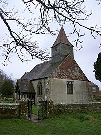
The parish church is St Bartholomew.
There is one public house in the village: the Yew Tree Inn.
History of the villages
The Romans built a road through the village and through Ripe, and remains of the layout can still be seen.
In the Middle Ages the area had a profitable wool trade.
| ("Wikimedia Commons" has material about Chalvington) |
