Christmas Common
| Christmas Common | |
| Oxfordshire | |
|---|---|
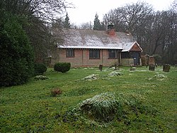
 Former Chapel of the Nativity | |
| Location | |
| Grid reference: | SU713932 |
| Location: | 51°38’2"N, 0°58’12"W |
| Data | |
| Post town: | Watlington |
| Postcode: | OX49 |
| Dialling code: | 01491 |
| Local Government | |
| Council: | South Oxfordshire |
| Parliamentary constituency: |
Henley |
| Website: | Watlington Parish Council |
Christmas Common is a hamlet by Watlington (into which civil parish it falls) in Oxfordshire, about seven and a half miles south of Thame and close to the boundary with Buckinghamshire. The hamlet is 812 feet above sea level on an escarpment of the Chiltern Hills. Because of its elevation, Christmas Common has two radio masts that are prominent local landmarks.
The hamlet's unusual name is of uncertain origin. It is variously ascribed to a 1643 Christmas Day truce between combatants in the Civil War, to local holly tree coppices,[1][2] or the Christmas family, which had local connections.
Parish church
The parish church is appropriately called the Church of the Nativity. It was designed by the architect Walter Cave.[3] It was built in 1889 as a chapel of ease to save residents from walking 2 miles and back each Sabbath downhill to the service at the parish church, St Leonard's in Watlington. The Church of the Nativity was made redundant in the 20th century and is now a private house.
History
Watlington Park is a private park and country house about three-quarters of a mile southwest of Christmas Common. In 1675 Thomas Stonor of Stonor Park had a large house built here on an H-shaped plan. The Stonor family were recusants, and the house included a Roman Catholic chapel at which local Roman Catholics attended mass. Between 1716 and 1756 John Talbot Stonor, Vicar Apostolic of the Midland District was a frequent visitor.[2]
In the 1750s the Stonors sold the house to John Tilson, who had a new house built to a compact Palladian design and re-used at least part of the older house as servants' quarters. Late in the 19th and early in the 20th century, subsequent owners altered and enlarged the Tilson house. Oliver Brett, later Viscount Esher, bought Watlington Park in 1921 and continued enlarging and modernising it. In 1954 his successor Major Lionel Brett, an architect, demolished all the extensions and the remains of the 17th century Stonor house[2] and added pedimented pavilions of his own design.[4] In 1967 Lionel Brett, by now 4th Viscount Esher, built the modernist Tower House for himself in a wood away from the hamlet.[3]
Christmas Common has never been populous. The 1811 census named the hamlet as a liberty and reported that it had only six inhabited houses.[2]
Christmas Common was the home of philologist and lexicographer William Craigie for more than twenty years in his retirement, until his death in 1957.[5]
Amenities
The Chilterns are an Area of Outstanding Natural Beauty. The scarp slope of the Chilterns faces northwest from the hamlet steeply downhill towards Watlington.
The ancient Icknield Way follows the line of the Chilterns and is now a long-distance footpath. The Oxfordshire Way long-distance footpath passes through Christmas Common on its route between Bourton-on-the-Water and Henley-on-Thames, and crosses the Icknield Way a mile downhill from the village.[6] The surrounding beech woods and local rights of way are popular with walkers, cyclists, horse riders and birdwatchers. The National Trust provides a car park at Watlington Hill on the edge of Christmas Common.
The area is a good place to see red kites, which had been extinct in Britain but were successfully reintroduced in 1989.[7][8]
The hamlet has a public house and restaurant, the Fox and Hounds.
Outside inks
| ("Wikimedia Commons" has material about Christmas Common) |
References
- ↑ Mills & Room 2003, p. not cited.
- ↑ 2.0 2.1 2.2 2.3 Lobel 1964, pp. 210–252
- ↑ 3.0 3.1 Sherwood & Pevsner 1974, p. 543.
- ↑ Sherwood & Pevsner 1974, p. 831.
- ↑ Dictionary of National Biography, 1971, volume 1–21, page 267
- ↑ Thomas 1993, p. not cited.
- ↑ "Watlington Parish Council". http://www.watlington.org/. Retrieved 15 December 2008.
- ↑ "Where to see red kites in the Chilterns". Chilterns Conservation Board. http://www.chilternsaonb.org/downloads/publications/wheretoseekites.pdf. Retrieved 16 December 2008.
- Lobel, Mary D, ed (1969). A History of the County of Oxford: Volume 8: Lewknor and Pyrton Hundreds. Victoria County History. pp. 210–252.
- Mills, A.D; Room, A (2003). A Dictionary of British Place-Names. Oxford: Oxford University Press. ISBN 0-19-852758-6.
- Sherwood, Jennifer; Pevsner, Nikolaus (1974). Oxfordshire. The Buildings of England. Harmondsworth: Penguin Books. pp. 543, 831–832. ISBN 0-14-071045-0.
- Thomas, Gavin (1993). The Oxfordshire Way (A Walker's Guide). Stroud: Alan Sutton Publishing. ISBN 978-0-7509-0356-1.