Coldharbour, Essex
| Coldharbour | |
| Essex | |
|---|---|
 Coldharbour Point on the River Thames | |
| Location | |
| Grid reference: | TQ525785 |
| Location: | 51°29’22"N, 0°11’30"E |
| Data | |
| Post town: | Rainham |
| Postcode: | RM13 |
| Dialling code: | 01708 |
| Local Government | |
| Council: | Havering |
| Parliamentary constituency: |
Dagenham and Rainham |
Coldharbour is an isolated area with industrial buildings, barely even a hamlet now, in the marshes by the River Thames in south-western Essex. It is found south-west of the Rainham Marshes Nature Reserve.
At Coldharbour Point here, where the broad river turns, there has been a lighthouse since 1885. This point faces across the Thames to the town of Erith in Kent.
The nearest accessible settlement on land is the town of Rainham, to which it is connected by Coldharbour Lane. The village of Wennington is also nearby but not accessible by road: both are separated by the A13 and marshlands).
The area around the point is mainly industrial land known as the Freightmaster Estate depot. The London Loop passes through Coldharbour on its way east to Purfleet in Thurrock.
History
Coldharbour was an estate primarily in the ancient parish of Wennington. It included Little Coldharbour (also partly in Rainham), Coldharbour Point and Great Coldharbour. It was originally a marsh island.[1]
A ferry (known as the 'short ferry' in contrast to the 'long ferry' to London) operating from Coldharbour Point to Erith (then in Kent) on the southern bank of the Thames existed from the Middle Ages until the 19th century. Plaques entitled 'Pilgrim Ferry' commemorate this in Coldharbour and Erith.
Gallery
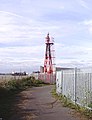
Coldharbour Point

Checkpoint on Coldharbour Lane, leading to the depot

A pipeline bridge on the Rainham Marshes

Cycleway 13, next to Coldharbour Lane
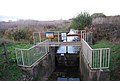
Sluice on a drainage ditch, Coldharbour Lane
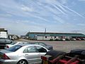
The Freighmaster Estate depot

Cleanaway’s waste transfer depot


