Denton, Norfolk
| Denton | |
| Norfolk | |
|---|---|
 Denton St Mary | |
| Location | |
| Grid reference: | TM281884 |
| Location: | 52°26’46"N, 1°21’20"E |
| Data | |
| Population: | 326 (2011) |
| Post town: | Harleston |
| Postcode: | IP20 |
| Dialling code: | 01986 |
| Local Government | |
| Council: | South Norfolk |
| Parliamentary constituency: |
South Norfolk |
| Website: | denton-norfolk.co.uk |
Denton is a village in the south pf Norfolk, four miles north-east of Harleston and thirteen miles south of Norwich. The 2011 Census recorded Denton with a population of 326,
History
Denton's name is of Anglo-Saxon origin and derives from the Old English for an enclosed farmstead or settlement in a valley.[1]
In the Domesday Book, Denton is listed as a settlement of 49 households in the Hundred of Earsham. In 1086, the village was divided between the estates of the King and Eudo, son of Spirewic.[2]
The village boundaries include the remaining earthworks of Denton Castle which was likely built in 1088 by William d'Albini and subsequently abandoned in 1254. Today, the castle is a scheduled monument and in the ownership of the National Trust.
St Mary's Church
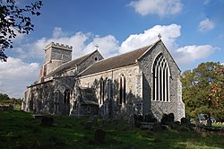
Denton's parish church, St Mary's, is of Norman origin. The church tower holds evidence of three major rebuilding efforts, the most notable in the Eighteenth Century in the Tudor Perpendicular Style. The stained glass dates back to the Mediæval period, with some examples installed by Le Grys Manfylde in the mid-Sixteenth Century.[3]
Denton war memorial takes the form of a carved marble plaque inside St. Mary's Church.
Outside links
| ("Wikimedia Commons" has material about Denton, Norfolk) |
References
- ↑ Place-Names
- ↑ Denton, Norfolk in the Domesday Book
- ↑ Knott, S. (2018). Retrieved December 22, 2022.
