Edlaston
| Edlaston | |
| Derbyshire | |
|---|---|
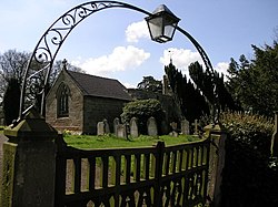
 St James' Church, Edlaston | |
| Location | |
| Grid reference: | SK176429 |
| Location: | 52°58’52"N, 1°43’48"W |
| Data | |
| Population: | 220 (2011) |
| Post town: | Ashbourne |
| Postcode: | DE6 |
| Local Government | |
| Council: | Derbyshire Dales |
Edlaston is a village three miles south of Ashbourne in Derbyshire, just off the A515 road. The wider parish includes the hamlet of Wyaston, which parish had a population of 220 at the 2011 Census.
Edlaston appears in Domesday Book as "Edolveston".
The village consists of a few farms and cottages and a traditional stone built public house, The Shire Horse.[1] To the west of the village is Edlaston Hall. It and its outbuildings have been converted to multiple dwellings.[2]
The church of St James has a chancel, nave, south porch and a square wooden turret which has bells. The 14th century masonry is complemented by windows and a roof of a later date. The church was repaired in 1682 and 1840, and was restored and reseated in 1870.
Robert Kaye Greville, a notable botanist did many drawings here in Edlaston and Wyaston as a child as his father, Robert Greville, was the local rector.
Outside links
| ("Wikimedia Commons" has material about Edlaston) |