Fleet, Lincolnshire
| Fleet, Lincolnshire | |
| Lincolnshire | |
|---|---|
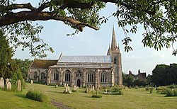
 Church of St Mary Magdalene, Fleet | |
| Location | |
| Grid reference: | TF388236 |
| Location: | 52°47’34"N, 0°3’30"E |
| Data | |
| Population: | 2,136 (2011[1]) |
| Post town: | Spalding |
| Postcode: | PE12 |
| Local Government | |
| Council: | South Holland |
| Parliamentary constituency: |
South Holland and The Deepings |
Fleet is a village and parish in the Holland part of Lincolnshire, within the Elloe Wapentake. It lies on Delph Bank, three miles south-east of Holbeach. The population of the civil parish, including Fleet Hargate, at the 2011 census was 2136.
In 1086, Fleet was listed as Fleot (Old English: the stream, estuary or creek), in the wapentake of Elloe in the Parts of Holland of Lincolnshire.[2]
The Grade-I-listed Church of England parish church, dating from the late 12th century, is dedicated to St Mary Magdalene.[3] The 120-foot church tower with spire is detached from the nave by 15 ft. The fabric is mainly Decorated in style, with Early English arcades and a Perpendicular west window. According to Cox (1916), the church was restored in 1860, when the chancel was rebuilt, although the canopied sedilia was retained.[4][5] In 1964 Pevsner noted 1798 repairs and considered the church "over-restored". He dated a chancel rebuild to 1843, questioned if it was "done correctly", and recorded Victorian tracery in the aisle windows, a blocked doorway to a previous chapel in the chancel, "fine busts of great variety", a Decorated-style sedilia and piscina with ogee arches and crocketed gables, a reredos dated 1790, and a defaced 14th-century effigy.[6]
Pevsner also recorded an 1854 red-brick rectory designed by Benjamin Ferrey, and a motte south-west of the village where 11th- and 12th-century pottery has been found.[6] The English Heritage record for the now ploughed-down motte site details finds from the Iron Age to the 18th century.[7][8]
References
- ↑ "Parish/Ward population 2011". Neighbourhood Statistics. Office for National Statistics. http://www.neighbourhood.statistics.gov.uk/dissemination/LeadKeyFigures.do?a=7&b=11123486&c=Fleet&d=16&e=62&g=6446974&i=1001x1003x1032x1004&m=0&r=1&s=1440413605170&enc=1. Retrieved 24 August 2015.
- ↑ Open Domesday Online: Fleet, Lincolnshire
- ↑ National Heritage List 1146568: Church of St Mary Magdalene
- ↑ Cox, J. Charles (1916) Lincolnshire pp. 126, 127; Methuen & Co. Ltd
- ↑ Kelly's Directory of Lincolnshire with the port of Hull 1885, p. 394
- ↑ 6.0 6.1 Pevsner, Nikolaus; Harris, John; The Buildings of England: Lincolnshire p. 526, 527; Penguin, (1964); revised by Nicholas Antram (1989), Yale University Press. ISBN 0300096208
- ↑ Historic England. "Monument No. 353734". PastScape. http://www.pastscape.org.uk/hob.aspx?hob_id=353734. Retrieved 5 July 2012
- ↑ TF38562311 Site of motte, south-west of Fleet
Outside links
| ("Wikimedia Commons" has material about Fleet, Lincolnshire) |