Grimley
| Grimley | |
| Worcestershire | |
|---|---|
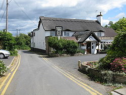
 Wagon Wheel Inn | |
| Location | |
| Location: | 52°14’31"N, 2°14’28"W |
| Data | |
| Population: | 640 (2021) |
| Post town: | Worcester |
| Postcode: | WR2 |
| Local Government | |
| Council: | Malvern Hills |
Grimley is a village and parish in the Oswaldslow hundred of Worcestershire, about three miles north of Worcester. It is known for the Norman Parish Church; St Bartholome, and nature reserve SSSI.
The villages of Sinton Green and Monkwood Green sit within Grimley Parish. The parish had a population of 640 in 2021.[1]
History
The place-name 'Grimley' is first attested in a Saxon charter of 851, where it appears as Grimanlea. In the Domesday Book of 1086 it appears as Grimanleh. The name means 'wood haunted by a ghost or spectre' (Old English grima).[2]
It once housed a monastery which was reputedly linked to Holt Castle via tunnels, and has been a site of refuge for thousands of years.
Following the Poor Law Amendment Act 1834, Grimley Parish ceased to be responsible for maintaining the poor in its parish. This responsibility was transferred to Martley Poor Law Union.[3]
References
- ↑ "Grimley". https://citypopulation.de/en/uk/westmidlands/admin/malvern_hills/E04010303__grimley/.
- ↑ Eilert Ekwall, The Concise Oxford Dictionary of English Place-names, p.205.
- ↑ Worcestershire Family History Guidebook, Vanessa Morgan, 2011, p68 The History Press, Stroud, Gloucestershire.
Outside links
| ("Wikimedia Commons" has material about Grimley) |
- "Grimley Gravel Pools". West Midland Bird Club. http://www.westmidlandbirdclub.com/worcs/grimley/.
- A walk around Grimley
- St. Bartholomew's Church
- List of Rectors, 1269-1988