Imber
| Imber | |
| Wiltshire | |
|---|---|
 Imber urban warfare training area | |
| Location | |
| Grid reference: | ST965485 |
| Location: | 51°14’2"N, 2°3’4"W |
| Data | |
| Population: | 0 |
| Postcode: | SN10 |
| Local Government | |
| Council: | Wiltshire |
| Parliamentary constituency: |
South West Wiltshire |
Imber is a deserted village in part of the Army's training grounds on the Salisbury Plain, in Wiltshire. It is situated in an isolated area of the Plain, about two and a half miles west of the A360 road between Tilshead and West Lavington.
This was once an agricultural village like many others on and around Salisbury Plain, but in 1943, during the Second World War, the entire civilian population was evicted to provide an exercise area for American troops preparing for the invasion of Europe. After the war, the villagers were not allowed to return to their homes, and it has remained deserted ever since.
The village remains under the control of the Ministry of Defence despite several attempts by former residents to return. Non-military access is limited to several open days a year.[1]
Contents
History
Early history
Settlement in the area began before the period of Roman rule, in the Iron Age or earlier. Several ancient trackways lead to and from the village.
The first documentary evidence of Imber's existence comes from Anglo-Saxon times, with a mention of the village in 967. Imber is also recorded in the Domesday Book, at which time it is believed to have had a population of around fifty.
The village's church of St Giles dates from the 13th century and has notable wall-paintings from the 15th. By the 14th century the population of the village had risen to around 250, where it is believed to have remained until the 19th century. Population peaked at 440 as recorded in the census of 1851, declining to around 150 by the time of Imber's abandonment.
Imber was always an isolated community, Salisbury Plain being relatively sparsely populated, and most of its residents were employed in agriculture or work that directly depended on it.[2] The village had an elongated form like a linear village, and its main street followed the course of a stream known as Imber Dock. The only building to survive in a reasonable condition is the church, with the rest becoming derelict or demolished by the Army. In 1943 there was also a Baptist chapel (built in 1839, demolished in late 1970s), a post office, and a pub called the Bell Inn, which still stands; as does the manor house, Imber Court. Also still standing are a farmhouse, farm cottages, schoolroom and four "council house" type blocks built in 1938.
Eviction and military use

In the late 19th century the War Office began buying land on Salisbury Plain, primarily to the east of Imber, and using it for manœuvres. Beginning in the late 1920s farms around Imber were purchased, as well as the land on which the village itself sat. The pressures of agricultural depression, combined with the good prices offered by the military, encouraged the sale of land, with few being put off by the new conditions of their tenancy. This allowed the War Office to assume control and evict the residents if necessary. By the time of the Second World War, almost all of the land in and around Imber, with the exception of the church, vicarage, chapel, schoolroom and Bell Inn, belonged to the War Office.
On 1 November 1943, with preparations for Operation Overlord, the Allied invasion of mainland Europe, under way, the people of Imber were called to a meeting in the village schoolroom and given 47 days' notice to leave their homes. Imber was to be used by American soldiers to practise street fighting. Richard Madigan's evidence to the Defence Lands Committee stated that street fighting practice never took place and that his, and others', duties were to keep the village in good repair for the villagers' eventual return. The reason for eviction was the village's proximity to shell impact areas. Although upset about being forced to leave, most villagers put up no resistance, even leaving canned provisions in their kitchens and taking the view that it was their duty to contribute to the war effort in this way – making sacrifices on the Home Front for the greater good. Compensation for the move was limited, and the occupants of one farm had to be forcibly evicted by the Army. Albert Nash, who had been the village's blacksmith for over forty years, is said to have been found sobbing over his anvil: became the first evicted resident to die and be brought back to Imber for burial.[3]
After the war, the village was not returned to the villages. Instead it was used extensively for training, particularly preparing soldiers for their duties in the urban environments of Northern Ireland. Several empty house-like buildings were constructed during the 1970s to aid training, and it is these, along with the church, Bell Inn and Imber Court, that are Imber's most striking buildings today. Although training continues at Imber, a purpose-built urban warfare complex for close quarters battle at Copehill Down (approx three miles south-east) has recently been the focus of this type of training, as that site is easier to adapt to reflect the areas in which troops are likely to be deployed.
Restoration attempts
Many of the village's buildings suffered shell and explosion damage after the war when British military operations began, and, additionally eroded by the weather, quickly fell into disrepair. Although the villagers had been told they could return in six months, this was never allowed. Documentary evidence of a return agreement only came to light at the Defence Land Committee hearings. At the end of the war, efforts were made to restore Imber to its pre-war condition – although there was very little damage – but the decision was taken not to relinquish control.
A rally in the village was organised in 1961 to demand that the villagers be allowed to move back, and over 2,000 people attended, including many former residents. A public inquiry was held, but his was at the height of the Cold War and the inquiry found in favour of Imber's continued military use.[4]
The matter was also raised in the House of Lords, and it was decided that the church would be maintained, and would be open for worship on the Saturday closest to St Giles's day each year, a practice that continues.
A further attempt to restore Imber took place in the early 1970s when the Defence Lands Committee was given the task of looking into the need for the retention of MoD lands. The Imber case was represented before the Committee by David J Johnson, an Imber researcher; Richard Madigan, a former soldier who helped to evacuate the village, and who and testified to the promise of return after the war, and Rex Mutters, a wartime fighter pilot.[5] They were assisted by Austin Underwood, who had led the campaign in the early 1960s and backed-up with written evidence from former villagers. In spite of all the additional evidence, including the first re-appearance since 1943 of the original eviction letter (which indicated return),[6] the Committee recommended that the village be retained for military use.[7]
The Bell Inn was sold to the Ministry of Defence in the mid-1950s and the Baptist Chapel in the late 1970s, leaving only the parish church in other ownership.
St Giles Parish Church

The Church of St Giles in Imber is a Grade I listed building.[8] It remains consecrated and a service is held there once a year, but the church has suffered severe material decline since it was abandoned, and it is now classified as a redundant church.
Before the village was evacuated, Imber was an ecclesiastic parish in its own right and St Giles was the parish church, but it has since been integrated with the parish of Edington, a village to the north, to create the Parish of Edington-with-Imber, in which there is another ancient listed church; Edington Priory.
While the rest of the parish belongs to the Crown, St Giles's church and its graveyard remain in the ownership of the Church of England, and the Diocese of Salisbury, although access was and is controlled by the Ministry of Defence.
By 2001 it had become clear, according to a Church of England press release, that St Giles's "was in need of extensive repairs." Since it was "not possible for the parochial church council to accept liability for the maintenance of a building to which they only had effective access for worship once a year", the Edington-with-Imber PCC requested that Imber church be declared redundant, setting in train a process which ended in 2005 with the vesting of the church in the Churches Conservation Trust.
In 2003 the church tower was struck by lightning, weakening the structure. Nevertheless, restoration work commenced in 2008 and the annual service resumed in September 2009 on completion of the works.
The annual church service, on the Saturday nearest to St Giles Day, has been attended by former residents including Ken Mitchell (grandson of Albert Nash); the son of the last schoolmistress, John Williams; soldiers who have used the village for training, and the general public. The village is open to visitors on other occasions; generally these are certain Bank Holidays and around Christmas. From 2009 to 2012 there has been a Carol service on the Saturday before Christmas.
Census
Imber is still included in the census records. The population reached its peak of 440 persons in 1851 which had declined to 152 by 1931 when the last occupied census was taken. The next census after 1931 was in 1951 when the number of residents was listed as "0", a situation which continues to be shown on census results.
Popular culture
Imber features in the film Catch Us If You Can (1965), the debut feature film of director John Boorman and a starring vehicle for the British pop group The Dave Clark Five.
In Victor Canning's 1972 novel for teenagers The Runaways, the cheetah that has escaped from Longleat Safari Park makes a den on the firing range close to Imber and her cubs are found there by the young hero Smiler.[9]
The 2013 novel The Sea Change by Joanna Rossiter centres on the evacuation of Imber, and the subsequent experiences of fictional characters from the village in the war and post-war years.[10]
Neil Spring's 2017 novel The Lost Village, a ghost story featuring ghost hunter Harry Price, is set in Imber.[11]
Pictures


The former Seagrams Farm

Houses used for training purposes
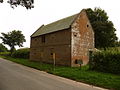
This building was a pub known as The Bell

Imber Court building


Monument to victim of highwaymen, Imber Range


See also
- Tyneham – another village taken over for military purposes
Outside links
| ("Wikimedia Commons" has material about Imber) |
- Parish of Heytesbury, Imber, Knook and Tytherington
- St Giles Church
- Information about access to Imber from public-interest.co.uk
- Gallery of photos of Imber from ThincTanc
- Maps and photos of the church
- 2003 arts event at Imber
- Review of the 2003 arts event at Imber in The Times
- Imber: An English Ghost Town — slideshow by Life magazine
- Audio slideshow: The lost village of Imber — audio slideshow by the BBC.
- Wiltshire County Council. "Wiltshire Community History: Imber"
- BBC Wiltshire Villages. "The plight of the church at Imber"
References
- ↑ lost village of Imber
- ↑ "Imber". http://www.abandonedcommunities.co.uk/imber.html. Retrieved 20 August 2016.
- ↑ "The secrets of Britain's abandoned villages". BBC News. http://www.bbc.co.uk/news/magazine-11765712. Retrieved 20 August 2016.
- ↑ Sawyer 2001, pp. 145–152
- ↑ Sawyer 2001, pp. 158–159
- ↑ Sawyer 2001, pp. 158
- ↑ Sawyer 2001, pp. 159
- ↑ National Heritage List 1036472: Church of St Giles, Heytesbury
- ↑ Victor Canning (1972). The Runaways. Heinemann Educational. ISBN 978-0-435-12180-8. https://books.google.com/books?id=bHFmAAAACAAJ.
- ↑ Rossiter, Joanna: 'The Sea Change' (Penguin, 2013) ISBN 978-0-241-96416-3
- ↑ Spring, Neil: 'The Lost Village: The Ghost Hunters (2)' (Quercus, 2017) ISBN 978-1-78429-861-6
Books
- Bodington, E.J.: 'The Church Survey in Wiltshire 1649–50': Wiltshire Archaeological and Natural History Magazine, Volume 41, pages 23–5 (1919)
- Glanfield, Edgar: 'The Dew Pond Makers of Imber': Wiltshire Archaeological and Natural History Magazine, Volume 42, pages 73–5 (1922)
- Kite, Edward: 'Imber and Imber Court': Wiltshire Archaeological and Natural History Magazine, Volume 41, page 212 (1922)
- Ponting, C.E.: 'Church of St. Giles, Imber': Wiltshire Archaeological and Natural History Magazine, Volume25 pages 13–15 (1889)
- Powell, J.U.: 'The Derivation of Imber': Wiltshire Archaeological and Natural History Magazine, Volume 40, page 362 (1919)
- Revels, G.S.: 'A Thousand years of History: a short guide to St Giles Church and the Parish of Imber' (c. 1972)
- Sawyer, Rex: 'Little Imber on the Down: Salisbury Plain's Ghost Village' (Hobnob Press, 2001) ISBN 0-946418-06-3