Kenton, Middlesex
| Kenton | |
| Middlesex | |
|---|---|
.jpg) The Travellers Rest pub, Kenton | |
| Location | |
| Grid reference: | TQ175885 |
| Location: | 51°35’16"N, 0°18’31"W |
| Data | |
| Population: | 35,600 (est) |
| Post town: | Harrow |
| Postcode: | HA3 |
| Dialling code: | 020 |
| Local Government | |
| Council: | Brent / Harrow |
| Parliamentary constituency: |
Brent North / Harrow East |
Kenton is a suburban village in northern Middlesex, contiguous with its neighbours in the metropolitan conurbation that fills the county. The main road through the area is Kenton Road. A distinct area, South Kenton is to the south.
Contents
History
_p069_-_Harrow_on_the_Hill.jpg)
.jpg)
The hamlet was recorded as "Keninton" in 1232. The name derives from the Old English Cæninga tun, meaning 'Cæna’s family’s farmstead', after the landowners here, who are otherwise unknown to history.
Before the 20th century, the tiny settlement was concentrated around in what was Kenton Lane (the easternmost part of which remains as Old Kenton Lane to the east of Kingsbury station) and is now part of the present day Woodgrange Avenue and Kenton Road.
Kenton station was opened by the London and North Western Railway on 15 June 1912. The Metropolitan Railway's Northwick Park and Kenton station (later renamed Northwick Park) followed on 28 June 1923.
The coming of the railways was soon followed by suburban development, most of Kenton being built between the Wars.
The London County Council built the Kenmore Park cottage estate between the wars. There are 654 houses on the 58 acres site.
Thomas Francis Nash owned building companies which from the 1920s onward built numerous private housing estates in Kenton, Ruislip and other parts of the "Metroland" area of Middlesex. F. & C. Costin was another local building company that built much of Kenton between the wars. Local estate agents still use the term "Nash-built" or "Costin-built" to describe properties built by them in Kenton.
Historically a village at the northern tip of Woodcock Park, Kenton's centre moved towards Wealdstone after the opening of Kenton station on the London-Birmingham railway in 1912 and expansion of Kingsbury's boundaries, and Kenton and grew into a suburb by the 1920s. Kenton Road which runs through the area consists of wide pavements and a dual carriageway.[1]
The South Kenton area is distinct from Kenton, being almost contiguous with North Wembley and Preston.[2]
The Wealdstone Brook source starts near the Kenton Recreation Ground and flows south-east towards the River Brent.
About the village

The Windermere is a Grade II listed public house in Windermere Avenue.[3] It is on the Campaign for Real Ale's National Inventory of Historic Pub Interiors[4] and was built in 1938.
The Plough public house was Kenton's first, opening in the early 18th century; the current building is not the original. It is now an Indo-Chinese fusion restaurant and bar called Blue Ginger.
Churches


Kenton has several churches, and places of worship for other religions.
- Methodist: Kenton Methodist Church,
- Independent / Evangelical: Kenton Evangelical Church
- Baptist: Kenton Baptist Church
- Roman Catholic: All Saints Church
- Greek Orthodox: Church of St Panteleimon[5] The building of St Panteleimon's dates back to 1932.[6]
By Woodcock Park is also a United Synagogue.[7]
There are two Hindu mandirs and a Jain Derasar
Parks and sports=
There are three large open spaces in Kenton: Woodcock Park, Kenton Recreation Ground, and Northwick Park directly to the west.
The Kenton Sports Club and its ground is located on Kenton Lane which consists of cricket, tennis and table tennis.[8]
Pictures
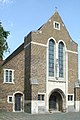
Front entrance to St Mary Church

Front entrance to St Mary Church
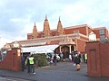
Shree Kutch Satsang Swaminarayan, Hindu mandir

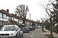
Lindsay Drive in Kenton
Abbott's Drive in South Kenton
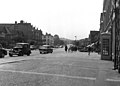
Kenton Road, near Kenton Park Parade, in 1955


Outside links
References
- ↑ https://www.harrow.gov.uk/downloads/file/26937/characterisation-study-of-harrow-2011
- ↑ https://hidden-london.com/gazetteer/kenton/
- ↑ National Heritage List 1350348: The Windermere public house (Grade II listing)
- ↑ Brandwood, Geoff (2013). Britain's best real heritage pubs. St. Albans: CAMRA. p. 89. ISBN 9781852493042.
- ↑ St Panteleimon
- ↑ http://www.st-panteleimon.org/about/
- ↑ Kenton Synagogue
- ↑ Kenton Lawn Tennis Club
- Ebdon, John: 'Ebdon's England' (David & Charles, 1985) ISBN 0-7153-8595-X