Mam Tor
| Mam Tor | |||
| Derbyshire | |||
|---|---|---|---|
 Mam Tor, July 2011 | |||
| Range: | Peak District | ||
| Summit: | 1,696 feet SK127836 53°20’57"N, 1°48’38"W | ||
Mam Tor is a hill of 1,696 feet in the Peak District, amongst the greater fells known as the High Peak, in Derbyshire. It stands close to Castleton, and south of Edale.
The name 'Mam Tor' is apparently from the Old British language; Mam means 'mother', so "mother hill", which may be because frequent landslips on its eastern face have resulted in a multitude of small daughter hills beneath it.[1] It has been noted elsewhere though that 'mam' may indicate 'breast', perhaps describing the shape of the hill.
The landslips which affect the eastern slope are caused by unstable lower layers of shale, and they give the hill its alternative name of Shivering Mountain.[2] In 1979 the continual battle to maintain the A625 road (Sheffield to Chapel en le Frith) on the crumbling eastern side of the hill was lost when the road officially closed as a through-route.
Contents
Caves
At the base of the Tor and nearby are four show caves: Blue John Cavern, Speedwell Cavern, the Devil's Arse and Treak Cliff Cavern where lead, Blue John, fluorspar and other minerals were once mined.
Geology

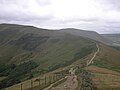
Mam Tor is on the southern edge of the Dark Peak (sandstones) and overlooks the White Peak (limestones), including the notable dry gorge of Winnats Pass. It is a dominating link between the eastern end of Rushup Edge and the western end of the Great Ridge, which together separate the Hope Valley to the south from Edale to the north, and is a popular ridgewalk.
Mam Tor is made of rocks of Carboniferous age, approximately 320 million years old. The base of Mam Tor is composed of black shales of the Bowland Shale Formation of Serpukhovian age overlain by tubiditic sandstone of the Mam Tor Sandstone Formation of Bashkirian age.[3]
Mam Tor landslide

The most notable feature of Mam Tor is the active landslip which invades its southeast side almost to the summit, and interrupts the ramparts of the hillfort, unless its builders used it as part of the defences. This rotational landslide began roughly 4,000 years ago. The toe is a debris flow. The landslide is due to weak shales underlying sandstones, a common phenomenon all around the Dark Peak, notably at Alport Castles, Longdendale, Glossop, and Canyards Hills, Sheffield. Indeed, three larger landslips occur on the north side of Mam Tor, one of them cutting the main ridge at Mam Nick which allows a minor road over into Edale; another creates the striking crag of Back Tor well seen from Mam Tor.[4]
Evidence for the continued movement of the slide mass is demonstrated graphically by the severe damage to the old Mam Tor road that traversed this flow. The road was built at the beginning of the 1800s and was subsequently relaid until local authorities closed it in 1979. Layers of tarmac and gravel are up to 6 feet thick in places, demonstrating the numerous efforts to keep the road open. A short tunnel could readily have been made avoiding the landslip zone, but the opportunity to exclude heavy business and lorry traffic from the middle of the National Park was preferred. A local diversion for light vehicles follows the limestone gorge of Winnats Pass. Sheffield-Manchester traffic must now make a slow and lengthy detour over the A628 Woodhead Pass. This is one of the most extreme cases of geological problems affecting main transport systems in Britain, comparable with the railway at Dawlish on the South Devon coast.
Current mean annual movement is "up to 0.25 m; this increases greatly when winter rainfalls exceed thresholds of both 210 mm/month and 750 mm in the preceding six months."[5]
The debris flow poses no threat to any inhabited buildings; however, small farm buildings lying in the flow's path may soon be overwhelmed assuming a flow rate similar to that of the present. The 2000 study suggests that deep drainage may be the most effective means of stabilising the flow, though this may not completely stop movement.
Hill fort
The summit of Mam Tor is encircled by a late Bronze Age and early Iron Age hill fort.
Radiocarbon analysis suggests occupation from around 1200 BC. The earliest remaining features are two Bronze Age burial mounds, one just below the summit and the other on the summit itself, though now buried under the paving. At a later stage over a hundred small platforms were levelled into the hill near the summit, allowing inhabited timber huts to be constructed. The hill fort and burial mounds are a Scheduled Ancient Monument.[6]
Pictures
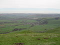
Castleton from Mam Tor
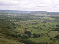
The Hope Valley
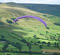
Paragliding from Mam Tor
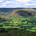
View from Mam Tor looking north towards the Vale of Edale
Path leading to Mam Tor from Lose Hill
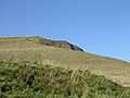
View of the summit from halfway
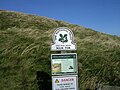
National Trust Sign


Outside links
| ("Wikimedia Commons" has material about Mam Tor) |
- Mam Tor Landslide British Geological Survey
References
- ↑ Mam Tor - National Trust
- ↑ Natural Curiosities of Derbyshire, in: The Every-day Book and Table Book; or, Everlasting Calendar of Popular Amusements, Sports, Pastimes, Ceremonies, Manners, Customs, and Events, Each of the Three Hundred and Sixty-Five Days, in Past and Present Times; Forming a Complete History of the Year, Months, and Seasons, and a Perpetual Key to the Almanac, Including Accounts of the Weather, Rules for Health and Conduct, Remarkable and Important Anecdotes, Facts, and Notices, in Chronology, Antiquities, Topography, Biography, Natural History, Art, Science, and General Literature; Derived from the Most Authentic Sources, and Valuable Original Communication, with Poetical Elucidations, for Daily Use and Diversion. Vol III., ed. William Hone, (London: 1838) p 11–16
- ↑ Waters, C. N. and Davies S. J. (2006) Carboniferous: extensional basins, advancing deltas and coal swamps - Chapter 9 of Brenchley, P. J. and Rawson P. F. (editors) (2006) The Geology of England and Wales, 2nd edition, London, The Geological Society
- ↑ Cooper, R. and Jarman, D. 2007. Mam Tor, in Mass Movements in Great Britain, JNCC, 167-184
- ↑ Waltham & Dixon (2000), Movement of the Mam Tor landslide, Derbyshire, UK, The Quarterly Journal of Engineering Geology and Hydrogeology, Volume 33, Number 2, May 2000, pp. 105–123(19)
- ↑ National Heritage List 1011206: Slight univallate hillfort and two bowl barrows on Mam Tor
Books
- Coombs, D. G.; Thompson, F.H. (1979), "Excavation of the hillfort of Mam Tor, Derbyshire", Derbyshire Archaeological Journal 99: 7–51
| The Seven 'Wonders of the Peak' in Derbyshire |
|---|
|
Chatsworth House • Devil's Arse • Ebbing and Flowing Well • Eldon Hole • Mam Tor • Poole's Cavern • St Ann's Well |