Poynings
| Poynings | |
| Sussex | |
|---|---|
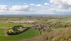
 Poynings from the South Downs | |
| Location | |
| Grid reference: | TQ264120 |
| Location: | 50°53’40"N, 0°12’13"W |
| Data | |
| Population: | 287 (2011) |
| Post town: | Brighton |
| Postcode: | BN45 |
| Dialling code: | 01273 |
| Local Government | |
| Council: | Mid Sussex |
| Parliamentary constituency: |
Arundel and South Downs |
| Website: | Poynings village |
Poynings is a village in Sussex, under the scarp of the South Downs. To its west is the Fulking parish, to its east is the Newtimber parish.
The village is located near Devil's Dyke, five miles north-west of Brighton. The civil parish population was recorded as 432 at the 2011 Census.
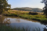
Poynings is a little village on the north side of the Downs. Its church is cathedral-like and comparable to Alfriston church without the spire. There is a public house, the Royal Oak, in the village which is a popular stop off point for walkers ascending the scarp slope. Also of note are the large ponds fed from the Downs, including the Poynings springhead.
The downland scarp, which includes the Fulking and Perching bostals (paths), is part of the an area designated as an Site of Special Scientific Interest by the name 'Beeding Hill to Newtimber Hill'.
Name
The area was known as “Puningas” in a record of 960. The origin of the name is uncertain but appears to be the common Saxon form for "sons of Puna" or "people of Puna", after an otherwise unknown progenitor with a form of name otherwise unknown from the period Others have suggested it means, “The people of the pond”.[1]
Church
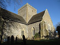
The Parish Church, the Church of the Holy Trinity, is at the east end of the village, on The Street. The church is a Grade I listed building.[2]
Holy Trinity has been described as 'One of the finest village mediæval churches in Sussex' (List Entry Number 1285135, first listed 28 October 1957).[2]
A church here is recorded in the Domesday Book. The current church though was built by the de Poynings family in 1370.[3] Its similarity to Alfriston church have left some people speculating that it had the same master mason architect.
The church has an echoing empty interior and scant signs of the wealth of the donor family. There are only the smallest fragments of fourteenth century glass surviving in the plain glass windows. With its big, centralised, empty interior it has been noted that it feels more like a grand old mosque than the usual homely busy-ness of many mediæval parish churches.
Historic monuments around the parish
A bowl barrow is found on Scabes Castle.[4] It was originally a circular funerary monument, now a roughly oval mound, having been levelled by modern ploughing on its eastern side.
The Devil's Dyke [5], is a large univallate hillfort dating to the Iron Age, on a chalk spur which forms part of the Sussex Downs.
A post-mediæval stock enclosure at Devil's Dyke is also a scheduled monument.[6] It survives as a north east-south west aligned, rectangular earthwork. It was used for the stalling of working oxen and as winter housing for fatstock cattle. Before excavation in 1908, it was assumed to be a burial mound.
A Romano-British farmstead 1,575 feet north-west of Devil's Dyke Cottages survives largely in buried form and is visible as an area of hollows and uneven ground.[7]
Outside links
| ("Wikimedia Commons" has material about Poynings) |
- Poynings village
- Poynings Parish Council
- The Downland Benefice: Poynings Church
- Roughwood web site: Holy Trinity, Poynings, West Sussex - Photographs of the church, taken on 18 January 2004
References
- ↑ Marshall, Sheila. "About Poynings: A Brief History of Poynings" (in en-GB). https://poynings.net/poynings.
- ↑ 2.0 2.1 National Heritage List 1285135: Church of the Holy Trinity (Grade I listing)
- ↑ A History of the County of Sussex - Volume 7 pp 208-212: Parishes: Poynings (Victoria County History)
- ↑ National Heritage List 1014950: Bowl barrow on Scabes Castle (Scheduled ancient monument entry)
- ↑ National Heritage List 1014953: Devil's Dyke (Scheduled ancient monument entry)
- ↑ National Heritage List 1014954: Post-mediæval stock enclosure at Devil's Dyke (Scheduled ancient monument entry)
- ↑ National Heritage List 1017649: Romano-British farmstead north-west of Devil's Dyke Cottages (Scheduled ancient monument entry)

