Prestongrange
| Prestongrange | |
| East Lothian | |
|---|---|
 Prestongrange House | |
| Location | |
| Grid reference: | NT378736 |
| Location: | 55°57’7"N, 2°59’46"W |
| Data | |
| Post town: | Prestonpans |
| Postcode: | EH32 |
| Dialling code: | 01875 |
| Local Government | |
| Council: | East Lothian |
| Parliamentary constituency: |
East Lothian |
Prestongrange is a place in the parish of Prestonpans, East Lothian, adjacent to the border with Midlothian. It is situated between Musselburgh to the west, and Prestonpans itself to the east. It forms the westernmost point of the county.
The placename derives from "Preston", meaning "priest's town", and a grange (or granary) which was worked by the Cistercian monks of Newbattle Abbey.
In the 16th century the Morrison family owned the Prestongrange lands. Their name survives in the present-day Morrison's Haven, the harbour of Prestongrange.
In the early 17th century, Mark Ker took possession of the lands from the abbey, and after the Grant Suttie family took over, the Prestongrange Colliery was no longer productive and fell into disuse.
In 1830, Sir George Grant Suttie leased Prestongrange Colliery to Matthias Dunn, the Inspector of Mines.
Places of interest
- Prestongrange Industrial Heritage Museum
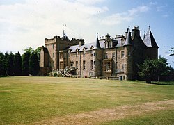
- Prestongrange House, now the headquarters of the Royal Musselburgh Golf Club
- Prestongrange Parish Church
Outside links
| ("Wikimedia Commons" has material about Prestongrange) |