Studland
| Studland | |
| Dorset | |
|---|---|
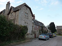
 Church Road and vicarage, Studland | |
| Location | |
| Grid reference: | SZ036825 |
| Location: | 50°38’31"N, 1°57’10"W |
| Data | |
| Population: | 425 |
| Post town: | Swanage |
| Postcode: | BH19 |
| Dialling code: | 01929 |
| Local Government | |
| Council: | Dorset |
| Parliamentary constituency: |
South Dorset |
Studland is a village on the Isle of Purbeck in Dorset. It is famous for its beaches and national nature reserve on Studland Bay.
The village and the bay are to be found two miles north of the town of Swanage, from which Studland is parted by a steep chalk ridge. Three miles to the north is Sandbanks; the uttermost village attached to the 'South East Dorset conurbation', but Studland is separated from Sandbanks by the beach and the narrows at the mouth of Poole Harbour.
The parish includes Brownsea Island within Poole Harbour.[1]
At the 2011 census the parish had 182 households and a population of 425, though many of the houses in the village are holiday homes, second homes, or guest houses, and the village's population varies wildly depending on the season.
Contents
About the village
Studland is sited in the lee of Ballard Down, close to the east-facing Studland Bay, a long curved sweep of sandy beaches two and a half miles long backed by dunes and heathland. The beaches are named South Beach, Middle Beach and Knoll Beach, with another at Shell Bay to the north.
Although a coastal village, the houses in Studland are mostly sited a few hundred yards inland. At the start of the twentieth century Sir Frederick Treves described the village as
"a medley of country lanes, lost among trees, with a few thatch-roofed cottages dotted about in a wild garden of brambles, ferns, and gorse."
He noted that Studland had "no pretence to a quay", but rather "turns its face from the sea to bury it among its myrtles and fuchsia bushes." He lamented the arrival of tourists and the construction of villas in the village however, commenting that "The red brick epidemic ... has seized upon it mercilessly."[2]
Since Treves' time the village has expanded with more buildings filling in gaps along its streets, much of the construction taking place in the early and mid 20th century, plus some more recently.[3]
Few ancient buildings remain in the village today, with the notable exception of the parish church.
Parish church
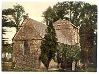
The parish church is St Nicholas. It is a Norman church, with construction dating probably from around 1180. It is largely unaltered from the Norman age,[4] in contrast to the recent appearance the rest of the village.
Close to the church is a modern Celtic cross, which was erected in 1976 and uses the old Saxon cross foundation as its base.[3]
Oilfield
The heath and harbour are home to Britain's largest onshore oil field, and Perenco's Wytch Farm gathering station is hidden amongst a pine forest to the west of the heath.
History
The existence of salt pans and salt workers at Studland is recorded in the Domesday Book of 1086.[5]
The current parish church, dedicated to the patron saint of sailors, St Nicholas,[4] is built on the site of an earlier Saxon building which was destroyed by the Danes in the 9th century, and had itself been constructed on an earlier, possibly pre-Christian foundation.[6]
Records from 1340 show that fishing was an important industry in Studland in the 14th century.[7]
In 1381 records show a castle existed on the cliffs at Handfast Point to the east of the village. By the 16th century this had been replaced with another castle, which existed until at least the 18th century when a blockhouse was added to it. Today nothing remains as the buildings were lost into the sea as a result of coastal erosion of the cliffs.[8]
The Royal National Institution for the Preservation of Life from Shipwreck stationed a lifeboat at Studland in 1826, but it was withdrawn in 1848.[9]
Second World War
In 1940, the coastline at Studland Bay was one of the two stretches of Dorset coast where a German invasion was considered most likely and it was fortified as a part of British anti-invasion preparations of Second World War.[10]
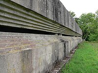
The village and beach were used as a training area before the D-Day landing in the Second World War. On top of Redend Point, a small sandstone cliff which splits the beach in two at high tide, is Fort Henry. Built in 1943 by Canadian engineers, it is 90 feet long, with walls 3 feet thick and a recessed observation slit 80 feet wide.
On 18 April 1944, King George VI, General Sir Bernard Montgomery and General Dwight D Eisenhower, met here to observe the training troops and discuss the plans for the coming battle.[11]
Studland in popular culture
- Egdon Heath, which figures prominently in Thomas Hardy's celebrated novel The Return of the Native, is a fictionalised version of the Poole basin heaths, most prominently the current Black Heath, Duddle Heath and Puddletown Heath around his birthplace, but including elements from Studland and Godlingston heaths.[12][13]
- The beach, with Bournemouth in the background, was the setting of the opening scene from the first episode of Monty Python's Flying Circus with Michael Palin staggering out of the shallow sea and collapsing on the beach before saying "It's..."[14]
- The beach scene set in Spain in the Only Fools and Horses episode "It Never Rains..." was filmed on Studland beach.
References
- ↑ Roland Gant (1980). Dorset Villages. Robert Hale Ltd. p. 220. ISBN 0 7091 8135 3.
- ↑ Sir Frederick Treves (1905). Highways and Byways in Dorset (1 ed.). Macmillan & Co. Ltd. pp. 191–2.
- ↑ 3.0 3.1 Steve White & Clive Hannay (August 2008). "In the footsteps of Treves - Studland". Dorset Life. http://www.dorsetlife.co.uk/2008/08/in-the-footsteps-of-treves-studland/. Retrieved 23 May 2013.
- ↑ 4.0 4.1 Reginald J W Hammond (1979). Dorset Coast (4 ed.). Ward Lock Ltd. p. 127. ISBN 0 7063 5494 X.
- ↑ J.H.Bettey (1974). Dorset. David & Charles. p. 39. ISBN 0 7153 6371 9.
- ↑ Roland Gant (1980). Dorset Villages. Robert Hale Ltd. p. 224. ISBN 0 7091 8135 3.
- ↑ J.H.Bettey (1974). Dorset. David & Charles. p. 80. ISBN 0 7153 6371 9.
- ↑ "Studland Village to Old Harry". southwestcoastpath.com. http://www.southwestcoastpath.com/walksdb/printable-walk/45/. Retrieved 19 May 2013.
- ↑ Denton, Tony (2009). Handbook 2009. Shrewsbury: Lifeboat Enthusiasts Society. p. 59.
- ↑ Foot, William (2006). Beaches, fields, streets, and hills ... the anti-invasion landscapes of England, 1940. Council for British Archaeology. pp. p65–72. ISBN 1-902771-53-2.
- ↑ "Wartime relics at Studland (with photo of Fort Henry)". http://www.tommythomas.org.uk/henry/index.htm. Retrieved 2 February 2007.
- ↑ "Thomas Hardy and his Wessex Place Names". Neal.oxborrow.net. http://neal.oxborrow.net/Thomas_Hardy/Hardyplacenames.htm. Retrieved 2013-03-27.
- ↑ "Hardy's Heath". Classprojects.kenyon.edu. http://classprojects.kenyon.edu/engl/exeter/Kenyon%20Web%20Site/Clare/Webpage-Heathinsight.html. Retrieved 2013-03-27.
- ↑ "The Isle of Purbeck On Screen". South-central-media.co.uk. http://www.south-central-media.co.uk/purbeck/purbeck.htm. Retrieved 2013-03-27.
- Foot, William (2006). Beaches, fields, streets, and hills ... the anti-invasion landscapes of England, 1940. Council for British Archaeology. ISBN 1-902771-53-2.
Outside links
| ("Wikimedia Commons" has material about Studland) |
- Studland Beach - Beach & Nature Reserve information at the National Trust
- Geology of Studland's south beach
- The Good Beach Guide: Studland - Knoll Beach
- The Good Beach Guide: Studland - Shell Bay

