Twyford, Norfolk
From Wikishire
| Twyford | |
| Norfolk | |
|---|---|
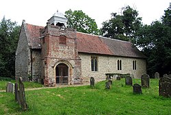
 St Nicholas's Church, Twyford | |
| Location | |
| Grid reference: | TG016245 |
| Location: | 52°46’50"N, 0°59’16"E |
| Data | |
| Population: | 26 (2001) |
| Post town: | Dereham |
| Postcode: | NR20 |
| Local Government | |
| Council: | Breckland |
| Parliamentary constituency: |
Mid Norfolk |
Twyford is a hamlet in Norfolk, on the A1067 road, seven and a half miles south-east of Fakenham and seventeen miles north-west of Norwich.
The wider civil parish had a population of 26 in 2001 and was not separately counted thereafter.
The name Twyford is from the Old English for a double ford.
Twyford Hall is a Grade II listed 17th-century country house, situated on the A1067 to the north of the hamlet.
St Nicholas's Church dates from Saxon times with a tower and porch from 1732 and later remodelling. The church is run as part of the 'Heart of Norfolk' group of rural parishes, with clergy based in North Elmham.[1]