Brompton, Shropshire
| Brompton | |
| Shropshire | |
|---|---|
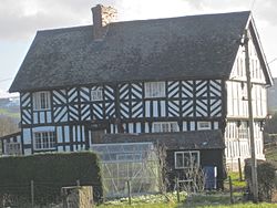
 The Lack, Brompton | |
| Location | |
| Grid reference: | SO249931 |
| Location: | 52°31’52"N, 3°6’22"W |
| Data | |
| Post town: | Montgomery |
| Postcode: | SY15 |
| Dialling code: | 01588 |
| Local Government | |
| Council: | Shropshire |
| Parliamentary constituency: |
Ludlow |
Brompton is a hamlet in Shropshire adjacent to the border with Montgomeryshire. It lies on the A489 road between Churchstoke and Newtown, at its junction with the B4385. Brompton forms a township of the ancient parish of Churchstoke and along with the adjacent Rhiston are the only two townships in Shropshire, as the rest of the parish lies in Montgomeryshire.
Brompton and Rhiston became a single civil parish in 1866, which merged with that of Chirbury to form Chirbury with Brompton in 1987.[1] Brompton remains in a separate ecclesiastical parish to Chirbury however.
The remains of three Roman marching camps have been found near Brompton.[2] The hamlet lies on Offa's Dyke, and the Offa's Dyke Path passes through. There is also an earthwork motte, which was in existence by 1225.[3]
The Lack is a Grade-II* Listed Building. It is likely to have been built in the latter part of the 16th century.[4]
There is a public house situated by the crossroads, called the Blue Bell.
References
- ↑ South Shropshire Parishes Order 1987
- ↑ Discovering Shropshire's History website
- ↑ Clwyd-Powys Archaeological Trust
- ↑ Moran M. (2003), Vernacular Buildings in Shropshire, Logaston Press pg. 396
| ("Wikimedia Commons" has material about Brompton, Shropshire) |